Page 1 of 25 1234511 ... LastLast
Results 1 to 20 of 495

Thread: Earthquakes, Plate Tectonics and Volcanism

  1. #1
    Banned
    Join Date
    Jul 2005
    Posts
    1,961
    Thanks
    0
    Thanked 0 Times in 0 Posts

    Default Earthquakes, Plate Tectonics and Volcanism

    Well, I can't think of a better title for this thread... so consider this a place to report and discuss the major happenings under our feet.

    The most recent Indonesian quake is topping the headlines, but it is just another manifestation here on the surface of the turmoil going on within the earth.

    I have seen one report which is really something extraordinary.

    At Lake Vui on the island of Ambae in the Vanuatu Rebpulic in the Pacific Ocean there has been a major change which occured almost overnight.

    The color of the lake turned from a turquoise-blue to a brilliant red.

    "Vui" in the native language means poison and Lake Vui has always been a turquoise-blue lake with a high acidic content. Some unprecidented, chemical subterranean change has occured which has turned Lake Vui to a bright red color.


    Associated Press

    Volcano's Lake Turns From Blue to Red
    By RAY LILLEY , 05.28.2006, 11:58 PM

    A lake atop a rumbling volcano on the South Pacific island of Ambae has changed color from blue to bright red, puzzling scientists.

    Mount Manaro, one of four active volcanos on the island nation of Vanuatu, has been showing signs of erupting for only the second time in 122 years.

    "We are still ... trying to understand this change of color in the lake from blue to red," Geology and Mines Department director Esline Garae said by telephone Monday from Vanuatu's capital, Port Vila.

    She said two scientists on Ambae Island were monitoring Lake Vui as well as seismic activity on the 5,000-foot Mount Manaro.

    If the change of color "comes from new activity in the ground or just chemical change in the lake - these are two things I want to know from those guys before I can say anything" about the danger posed by the volcano, she said.

    Mount Manaro last erupted in November 2005, forcing half the island's 10,000 inhabitants to evacuate their villages. An 1884 eruption killed scores of villagers.

    New Zealand volcanologist Brad Scott said Lake Vui's color was "quite a spectacular red," but what had caused it "is the $64,000-question."

    He said water samples from the lake would help determine what was happening in the crater and below it.

    The color change could be a chemical process or gas from molten volcanic rock or something else coming into the lake, he said.

    Three other volcanos in Vanuatu - Lopevi, Yasur and a two-crater volcano on Ambryn Island called Marum and Benbow - have spewed rocks, ash, smoke and steam in recent weeks.

    Vanuatu, formerly the New Hebrides Islands, is made up of 13 main islands located about 1,400 miles east of Australia.

    http://www.forbes.com/business/feeds...ap2778517.html


    Ambae Volcano - John Seach
    Ambae Island, Penama Province,
    Vanuatu
    15.38 S, 167.83 E,
    summit elevation 1496 m
    Shield Volcano


    Ambae is an elipsoid shield volcano in northern Vanuatu. The island forms the upper part of the most voluminous volcano in Vanuatu. Ambae volcano rises 3900 m above the ocean floor and has a volume of 2500 cubic km. Ambae is atypical because it has a significant volume of pyroclastic products compared to other basaltic shield volcanoes.

    Summit eruptions occurred at Ambae volcano in December 2005. People living in the north to the western side of the island reported smellingsulphuric fumes after an earthquake on February 16, 2005. There was an increase in water temperature at Ambae Volcano in 2000. Phreatic Eruptions occurred at Voui Crater Lake, Ambae in 1995


    Eruptions of Ambae Volcano
    2005, 1995 (lake degassing), 1914 (earthquake), 1870, 1670, 1575

    Three summit crater lakes at Ambae volcano:
    Lake Manaro Ngoru - 300 m diameter.
    Lake Vui (Voui) - 2.1 km diameter.
    Lake Manaro Lakua - 1.3 km diameter.
    Note on terminology:
    The correct name is Ambae Volcano.
    Other names used - Manaro, Aoba, Omba, Lombenben.

    http://www.volcanolive.com/ambae.html
    Last edited by Sean Osborne; May 30th, 2006 at 20:02.

  2. #2
    Forum General Brian Baldwin's Avatar
    Join Date
    Jul 2005
    Location
    Missouri
    Posts
    1,869
    Thanks
    0
    Thanked 2 Times in 2 Posts

    Default Re: Eathquakes, Plate Tectonics and Volcanism

    Great idea for a continuing thread Sean. I like it quite a lot. I think it's going to get a lot of use in the coming months.
    Brian Baldwin

    Yea though I walk through the valley of the shadow of death I shall fear no evil.... For I am the meanest S.O.B. in the valley.


    "A simple way to take measure of a country is to look at how many want in... And how many want out." - Tony Blair on America


    It is the soldier, not the reporter, who has given us freedom of the press.

    It is the soldier, not the poet, who has given us freedom of speech.

    It is the soldier, not the campus organizer, who has given us the freedom to demonstrate.

    It is the soldier who salutes the flag, who serves beneath the flag, and whose coffin is draped by the flag, who allows the protester to burn the flag.

    -Father Denis O'Brien of the United States Marine Corp.


    To view links or images in signatures your post count must be 15 or greater. You currently have 0 posts.

  3. #3
    Banned
    Join Date
    Jul 2005
    Posts
    1,961
    Thanks
    0
    Thanked 0 Times in 0 Posts

    Default Re: Eathquakes, Plate Tectonics and Volcanism

    Brian,

    No doubt. No doubt at all. Eventually there will come global quakes the likes of which mankind has never experienced.

    I am going to post a lot of background and current news as a sort of primer for this thread. To that end...


    TECTONICS
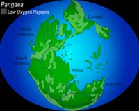
    How Did Continents Split

    A depiction of the supercontinent Pangaea some 250 million years ago shows regions where oxygen was insufficient for animal survival. Because oxygen levels decrease with increasing altitude, the more mountainous "hatched" areas would have prevented intermingling and reproduction between nearby animal populations. Throughout Earth's history, there have been six major continental assembly and breakup events, about 500 million years apart. Currently the Earth is in breakup cycle in which the Atlantic and Indian oceans are opening. Credit: Nicolle Rager, National Science Foundation, based on Pangaea map data, Paleogeographic Atlas Project, University of Chicago
    by Christina Dierkes
    Athens OH (SPX) May 25, 2006
    Like pieces in a giant jigsaw puzzle, continents have split, drifted and merged again many times throughout Earth's history, but geologists haven't understood the mechanism behind the moves. A new study now offers evidence that continents sometimes break along preexisting lines of weakness created when small chunks of land attach to a larger continent.

    The paper — the cover story in the latest issue of Geology, the journal of the Geological Society of America — is the first to provide an explanation for the breaking patterns of continental plates, and uses the formation of an ocean about 500 million years ago to demonstrate that principle.

    "We asked the question, 'Why do oceans open where they do, and why does a continent choose to break where it does?'" said Damian Nance, Ohio University professor of geological sciences and co-author of the study.
    Throughout Earth's history, there have been six major continental assembly and breakup events, about 500 million years apart. Currently the Earth is in breakup cycle in which the Atlantic and Indian oceans are opening, Nance said.
    The new study found that continents sometimes break along preexisting lines of weakness created during earlier continental collisions. Geologists had long suspected that break lines were created by the attachment of pieces onto larger land masses, but Nance and his co-authors were the first group to be able to prove this theory.

    About 650 million years ago – when the first jellyfish evolved – North America, South America and Africa were stuck together as one large continent called Gondwana, with some smaller islands floating on a neighboring continental plate. Over time, these islands collided with the large group of continents and were attached to it in a process called accretion.

    About 525 million years ago, that land mass broke apart, with North America on one side and South America, Africa and the small island pieces on the other. The two plates drifted apart, forming the Iapetus Ocean.
    Twenty-five million years later – at the time of the first fish and land plants – the strip of land that used to be the small islands broke off South America and Africa and began moving across Iapetus towards North America. This movement closed the Iapetus Ocean while at the same time opening the Rheic Ocean.

    Nance and his co-authors focused on these two particular breaks because they occurred along a "line of weakness" – namely the spot where the small islands had attached to the larger land mass. As the internal structure of the continent was already less stable there than it was across the two solid outside pieces, the continent broke along this preexisting line.

    The scientists used geochemical "fingerprinting" to show that the small pieces of land, which today are found in the Appalachians, were originally created in an ocean. The radioactive element Samarium, which breaks down into various types of the element Neodymium, was used to determine the age of the rock (about one billion years). The amount of each element was typical of rock created in the ocean, away from larger continental masses.

    The research is part of Nance's larger interest in the Rheic Ocean, which he has been studying for more than a decade. He is part of a multinational UNESCO project to examine the history of this ocean and has conducted work in Mexico and Europe. The present study was funded by the National Science Foundation, the Natural Sciences and Engineering Council of Canada, the Spanish Ministry of Education and Science and a Mexican Papiit Grant.
    The study's lead author was J. Brendan Murphy of St. Francis Xavier University, Antigonish, Canada. In addition to Nance, the other authors were Gabriel Gutierrez-Alonso of the Universidad the Salamanca, Salamanca, Spain; Javier Fernandez-Suarez of the Universidad Complutense, Madrid, Spain; J. Duncan Keppie of the Universidad Nacional Autonoma de Mexico, Mexico City, Mexico; Cecilio Quesada of IGME, Madrid, Spain; Rob A. Strachan of the University of Portsmouth, Portsmouth, Great Britain; and Jarda Dostal of St. Mary's University, Halifax, Canada.

  4. #4
    Banned
    Join Date
    Jul 2005
    Posts
    1,961
    Thanks
    0
    Thanked 0 Times in 0 Posts

    Default Re: Eathquakes, Plate Tectonics and Volcanism

    KEEP THIS LINK HANDY FOR CURRENT REFERENCE OF SEISMIC ACTIVITY

    http://earthquake.usgs.gov/eqcenter/recenteqsww/Quakes/quakes_all.php

  5. #5
    Banned
    Join Date
    Jul 2005
    Posts
    1,961
    Thanks
    0
    Thanked 0 Times in 0 Posts

    Default Re: Eathquakes, Plate Tectonics and Volcanism

    Seismologists Detect A Sunken Slab Of Ocean Floor Deep In The Earth

    Illustration of the Earth's core.
    by Staff Writers
    Santa Cruz CA (SPX) May 18, 2006
    Halfway to the center of the Earth, at the boundary between the core and the mantle, lies a massive folded slab of rock that once formed the ocean floor and sank beneath North America some 50 million years ago. A team of seismologists led by scientists at the University of California, Santa Cruz, detected the slab by analyzing seismic waves reflected from the deepest layer of the mantle beneath an area off the west coast of Central America.


    "If you imagine cold honey pouring onto a plate, you would see ripples and folds as it piles up and spreads out, and that's what we think we are seeing at the base of the mantle," said Alex Hutko, a graduate student in Earth sciences at UCSC and first author of a paper describing the new findings in the May 18 issue of the journal Nature.

    The discovery sheds new light on the processes that drive the movement of Earth's tectonic plates. The planet's outermost layer, or lithosphere, is broken into large, rigid plates composed of the crust and the outer layer of the mantle. New plate material is created at mid-oceanic ridges, where the ocean floor spreads apart, and old plate material is consumed in subduction zones, where one plate dives beneath another. But the fate of subducted lithosphere has been uncertain.

    "There is a big debate over whether subducted slabs sink all the way down to the base of the mantle or get trapped in the upper mantle. This is one line of evidence favoring the presence of subducted slabs in the deep mantle," said Thorne Lay, professor of Earth sciences at UCSC and coauthor of the Nature paper.

    "It's the first evidence from direct imaging to support the idea that ancient seafloor makes its way down to the bottom of the mantle," Hutko added.

    Within the mantle, which extends to a depth of about 1,740 miles, cold rock sinks while hot plumes rise toward the surface, and this slow circulation of mantle rock is thought to drive the movement of plates in the lithosphere. The base of the mantle absorbs heat from the core. The researchers were able to image the buckling and folding of subducted oceanic lithosphere at the base of the mantle because of the temperature difference between the relatively cool subducted slab and the hotter mantle rock surrounding it.

    The subducted slab is composed of essentially the same minerals as the surrounding mantle, but its temperature is about 700 degrees Celsius cooler, Hutko said. This temperature difference affects the location of a "phase transition," where the crystal structure of the mantle rock changes due to increasing pressure and temperature with depth. Seismic energy reflected by this phase transition revealed an abrupt step in the phase boundary about 60 miles (100 kilometers) high.

    "That's more than the thickness of the crust," Lay said. "It's a huge geological structure and it requires some large-scale dynamic process to produce it. A subducted slab piling up and spreading out is the only mechanism we know of that could give such an abrupt step."
    The researchers also saw evidence of hot plume-like structures at the edge of the slab, indicating possible upwelling of hot material from the base of the mantle as the spreading slab pushes into it.

    "We think there is a kind of pushing and bulldozing away of a hot basal layer of the mantle, giving rise to small plumes at the edges," Hutko said.
    The study used seismic data from earthquakes in South America that were recorded at seismographic stations in the western United States. The researchers analyzed the data using imaging techniques adapted from those used in oil exploration to study complex structures in the crust.
    "The oil industry has been using these techniques for decades, but only recently have we been able to exploit them for the deep Earth because of new data available from the seismographic network," Hutko said.

  6. #6
    Forum General Brian Baldwin's Avatar
    Join Date
    Jul 2005
    Location
    Missouri
    Posts
    1,869
    Thanks
    0
    Thanked 2 Times in 2 Posts

    Default Re: Eathquakes, Plate Tectonics and Volcanism

    http://dsc.discovery.com/convergence...teractive.html

    This link is to an interactive model of the Yellowstone Supervolcano. Very interesting to see how it affected our nation over millions of years. It will give you an idea of what will happen if it ever errupts in our lifetime.
    Brian Baldwin

    Yea though I walk through the valley of the shadow of death I shall fear no evil.... For I am the meanest S.O.B. in the valley.


    "A simple way to take measure of a country is to look at how many want in... And how many want out." - Tony Blair on America


    It is the soldier, not the reporter, who has given us freedom of the press.

    It is the soldier, not the poet, who has given us freedom of speech.

    It is the soldier, not the campus organizer, who has given us the freedom to demonstrate.

    It is the soldier who salutes the flag, who serves beneath the flag, and whose coffin is draped by the flag, who allows the protester to burn the flag.

    -Father Denis O'Brien of the United States Marine Corp.


    To view links or images in signatures your post count must be 15 or greater. You currently have 0 posts.

  7. #7
    Banned
    Join Date
    Jul 2005
    Posts
    1,961
    Thanks
    0
    Thanked 0 Times in 0 Posts

    Default Re: Eathquakes, Plate Tectonics and Volcanism

    So. San Andreas Fault Waiting to Explode

    Expert believes Los Angeles area at risk for massive earthquake

    June 21, 2006
    Reuters

    LONDON - The southern end of the San Andreas fault near Los Angeles, which has been still for more than two centuries, is under immense stress and could produce a massive earthquake at any moment, a scientist said Wednesday.

    Photo: California's Antelope Valley Freeway (Highway 14) cuts through the folded layers of the San Andreas Fault at Avenue S in Palmdale, Calif. (Roger Ressmeyer / Corbis file)

    Yuri Fialko, of the Scripps Institution of Oceanography at La Jolla, Calif., said that given average annual movement rates in other areas of the fault, there could be enough pent-up energy in the southern end to trigger a cataclysmic jolt of up to 32 feet (10 meters).

    "The observed strain rates confirm that the southern section of the San Andreas fault may be approaching the end of the interseismic phase of the earthquake cycle," he wrote in the journal Nature.

    A sudden lateral movement of 23 to 32 feet (7 to 10 meters) would be among the largest ever recorded.

    According to the U.S. Geological Survey, the earthquake that destroyed San Francisco in 1906 was produced by a sudden movement of the northern end of the fault of up to 21 feet (6.4 meters).

    Fialko said there had been no recorded movement at the southern end of the fault — the 800-mile-long (1,280-kilometer-long) geological meeting point of the Pacific and the North American tectonic plates — since the dawn of European settlement in the area.

    He said this lack of movement for 250 years correlated with the predicted gaps between major earthquakes at the southern end of the fault of between 200 and 300 years.

    Elsewhere on the fault, there were average slippage rates up to a couple of centimeters a year that prevented the build-up of explosive pressure deep underground.

    When these became blocked and then suddenly broke free, they produced tremors or earthquakes of varying intensity depending on the movement that had taken place before and the duration of the blockage.

    USGS says the most recent major earthquakes in the northern and central zones of the San Andreas fault were in 1857 and 1906.

    THREE POSSIBLE EXPLANATIONS

    Fialko said there were three possible explanations for the lack of observed movement in the southern section: creepage under the surface that had no external manifestation, a scenario in which the section simply doesn't not move as much as the rest of the section, or a major blockage.

    "Except for the first possibility above, the continued quiescence increases the likelihood of a future event," he wrote.

    Making calculations based on a wide range of land and satellite observations, he discounted the idea of creepage and warned of impending disaster.

    "Regardless of fault geometry and mechanical properties of the ambient crust, results presented in this study lend support to intermediate-term forecasts of a high probability of major earthquakes on the southern SAF system," Fialko said.

    Copyright 2006 Reuters Limited.

    http://www.msnbc.msn.com/id/13457472/


  8. #8
    Banned
    Join Date
    Apr 2006
    Posts
    232
    Thanks
    0
    Thanked 0 Times in 0 Posts

    Default Re: Eathquakes, Plate Tectonics and Volcanism

    I like this earthquake monitoring site as well: http://www.iris.edu/seismon/

  9. #9
    Banned
    Join Date
    Jul 2005
    Posts
    1,961
    Thanks
    0
    Thanked 0 Times in 0 Posts

    Default Re: Eathquakes, Plate Tectonics and Volcanism

    Mag. 6.3 earthquake stuck the the main Island of Hawai'i today. A Mag 5.8 followed 7-minutes later. Many multiple aftershocks continue.

    Details emerging.
    Last edited by Sean Osborne; October 15th, 2006 at 19:41.

  10. #10
    Banned
    Join Date
    Jul 2005
    Posts
    1,961
    Thanks
    0
    Thanked 0 Times in 0 Posts

    Default Re: Eathquakes, Plate Tectonics and Volcanism


  11. #11
    Banned
    Join Date
    Jul 2005
    Posts
    1,961
    Thanks
    0
    Thanked 0 Times in 0 Posts

    Default Re: Eathquakes, Plate Tectonics and Volcanism

    Earthquake Details

    Magnitude6.3 (Strong)
    Date-Time
  12. Sunday, October 15, 2006 at 17:07:49 (UTC)
    = Coordinated Universal Time
  13. Sunday, October 15, 2006 at 7:07:49 AM
    = local time at epicenter Time of Earthquake in other Time Zones
  14. Location19.878°N, 155.935°W
    Depth38.9 km (24.2 miles) set by location program
    RegionISLAND OF HAWAII, HAWAII
    Distances
  15. 10 km (6 miles) SW (231°) from Puako, HI
  16. 16 km (10 miles) WSW (245°) from Waikoloa Village, HI
  17. 19 km (12 miles) NNE (23°) from Kalaoa, HI
  18. 91 km (56 miles) WNW (282°) from Hilo, HI
  19. 253 km (157 miles) SE (129°) from Honolulu, HI
  20. Location UncertaintyError estimate not available
    ParametersNst=271, Nph=271, Dmin=23.3 km, Rmss=0 sec, Gp= 25°,
    M-type=moment magnitude (Mw), Version=7
    SourceUSGS NEIC (WDCS-D)
    Event IDustwbh

    • This event has been reviewed by a seismologist.

  21. #12
    Banned
    Join Date
    Jul 2005
    Posts
    1,961
    Thanks
    0
    Thanked 0 Times in 0 Posts

    Default Re: Eathquakes, Plate Tectonics and Volcanism

    Earthquake Details

    Magnitude5.8 (Moderate)
    Date-Time
  22. Sunday, October 15, 2006 at 17:14:09 (UTC)
    = Coordinated Universal Time
  23. Sunday, October 15, 2006 at 7:14:09 AM
    = local time at epicenter Time of Earthquake in other Time Zones
  24. Location19.946°N, 156.157°W
    Depth4.6 km (2.9 miles) (poorly constrained)
    RegionHAWAII REGION, HAWAII
    Distances
  25. 29 km (18 miles) NNW (327°) from Kalaoa, HI
  26. 31 km (19 miles) W (273°) from Puako, HI
  27. 38 km (24 miles) NNW (334°) from Kailua, HI
  28. 115 km (72 miles) WNW (284°) from Hilo, HI
  29. 231 km (143 miles) SE (131°) from Honolulu, HI
  30. Location Uncertaintyhorizontal +/- 10.4 km (6.5 miles); depth +/- 16.1 km (10.0 miles)
    ParametersNst=100, Nph=100, Dmin=68.6 km, Rmss=1.07 sec, Gp= 61°,
    M-type=body magnitude (Mb), Version=6
    SourceUSGS NEIC (WDCS-D)
    Event IDustwbi

    • This event has been reviewed by a seismologist.

  31. #13
    Expatriate American Patriot's Avatar
    Join Date
    Jul 2005
    Location
    A Banana Republic, Central America
    Posts
    48,612
    Thanks
    82
    Thanked 28 Times in 28 Posts

    Default Re: Eathquakes, Plate Tectonics and Volcanism

    People need to start paying attention to my constant warnings about "being prepared"
    Libertatem Prius!


    To view links or images in signatures your post count must be 15 or greater. You currently have 0 posts.


  32. #14
    Banned
    Join Date
    Jul 2005
    Posts
    1,961
    Thanks
    0
    Thanked 0 Times in 0 Posts

    Default Re: Eathquakes, Plate Tectonics and Volcanism

    FoxNews Alert:

    Hawaii Civil Defense Spokesman Says 95 Percent Of Oahu Is Without Power After Massive 6.3-Richter Magnitude Earthquake Strikes Off Hilo

  33. #15
    Senior Member
    Join Date
    Mar 2006
    Posts
    698
    Thanks
    0
    Thanked 0 Times in 0 Posts

    Default Re: Eathquakes, Plate Tectonics and Volcanism

    They updated Sean....

    == PRELIMINARY EARTHQUAKE REPORT ==

    ***This event has been revised.


    Region: ISLAND OF HAWAII, HAWAII
    Geographic coordinates: 19.880N, 155.937W
    Magnitude: 6.6 Mcd
    Depth: 39 km
    Universal Time (UTC): 15 Oct 2006 17:07:49
    Time near the Epicenter: 15 Oct 2006 07:07:49
    Local time in your area: 15 Oct 2006 17:07:49

    Location with respect to nearby cities:
    10 km (6 miles) SW (232 degrees) of Puako, HI
    17 km (10 miles) WSW (246 degrees) of Waikoloa Village, HI
    19 km (12 miles) NNE (22 degrees) of Kalaoa, HI
    91 km (57 miles) WNW (282 degrees) of Hilo, HI
    253 km (157 miles) SE (129 degrees) of Honolulu, HI

  34. #16
    Banned
    Join Date
    Jul 2005
    Posts
    1,961
    Thanks
    0
    Thanked 0 Times in 0 Posts

    Default Re: Eathquakes, Plate Tectonics and Volcanism

    As with the recent DPRK nuke test... Richter magnitude reports are adjusting upwards as more data points are fed into the equations.

    Richter Magnitude of todays quake is now 6.6

    I'll keep these reports to the basics because as with all recent disasters the media is unreliable and inconsistent, preferring to be first instead of accurate.

    Much of the Hawai'ian Islands are without power except for emergency generation. Landslides are reported and blocking at least one major highway, and a tsunami alert is still in effect.

    I got a real-time link with a NOAA observer feeding me data.
    Last edited by Sean Osborne; October 15th, 2006 at 22:33.

  35. #17
    Senior Member samizdat's Avatar
    Join Date
    Jun 2006
    Posts
    1,498
    Thanks
    16
    Thanked 1 Time in 1 Post

    Default Re: Eathquakes, Plate Tectonics and Volcanism

    I was flippin thru the Bible today and led to the "big one" Rev 16; 17-21.

    I hadn't read about the recent Hawaii earthquake.

    Underground nukes shake the earth plates, no?


    Bomb Tests and Earthquakes
    • Nuclear bomb testing has doubled the earthquake rate.
          • Gary Whiteford, Professor of Geography, University of New Brunswick

    • Abnormal meteorological phenomena, earthquakes and fluctuations of the earth's axis are related in a direct cause-and-effect to testing of nuclear devices.
          • Shigeyoshi Matsumae, President Tokai University Yoshio Kato, Department of Aerospace Science

    In the fifty years before testing, large earthquakes of more than 5.8 occurred at an average rate of 68 per year. With the advent of testing the rate rose "suddenly and dramatically" to an average of 127 a year. The earthquake rate has almost doubled.

    On June 19, 1992, the United States conducted an underground nuclear bomb test in Nevada. Another test was conducted only four days afterwards. Three days later, a series of heavy earthquakes as high as 7.6 on the Richter scale rocked the Mojave desert 176 miles to the south. They were the biggest earthquakes to hit California this century. Only 22 hours later, an "unrelated" earthquake of 5.6 struck less than 20 miles from the Nevada test site itself.

    62.5% of the killer earthquakes occurred only a few days after a nuclear test. Many struck only one day after a detonation. More than a million people have now died in earthquakes that seem to be related to nuclear tests.

    http://www.ratical.org/radiation/ine...tsNquakes.html

    canto XXV Dante

    from purgatory, the lustful... "open your breast to the truth which follows and know that as soon as the articulations in the brain are perfected in the embryo, the first Mover turns to it, happy...."
    Shema Israel

    To view links or images in signatures your post count must be 15 or greater. You currently have 0 posts.

  36. #18
    Expatriate American Patriot's Avatar
    Join Date
    Jul 2005
    Location
    A Banana Republic, Central America
    Posts
    48,612
    Thanks
    82
    Thanked 28 Times in 28 Posts

    Default Re: Eathquakes, Plate Tectonics and Volcanism

    In 1986 almost an entire village was wiped out by a lake that "turned blood red" and the following few days, a landslide into the lake causes the cap holding a massive amount of CO2 down rose to the surface, and poured through the area, killing hundreds around the lake.

    Only those who were sleeping high up survived. Everyone else was suffocated by the gas.

    I also saw a show on History Channel I think the other night about the "Exodus" which happened to mention that particular lake.

    They were doing a scientific study of the exodus the scientists involved have determined the dates (around 1500 BCE), the destruction of a an entire region caused by a volcano, Santorini -- west of Egypt and the rest of the middle east.

    The even were able to use that inforation to describe how the 10 plagues occurred. All very interesting. Probably pissed off a lot of people who want to say "it was God's Work" and those who think that it didn't happen at all... oh well.

    Anyway, good thread.

    I expect Yellowstone to go within the next 40-50 years.
    Libertatem Prius!


    To view links or images in signatures your post count must be 15 or greater. You currently have 0 posts.


  37. #19
    Banned
    Join Date
    Jul 2005
    Posts
    1,961
    Thanks
    0
    Thanked 0 Times in 0 Posts

    Default Re: Eathquakes, Plate Tectonics and Volcanism

    Quote Originally Posted by Rick Donaldson View Post
    In 1986 almost an entire village was wiped out by a lake that "turned blood red" and the following few days, a landslide into the lake causes the cap holding a massive amount of CO2 down rose to the surface, and poured through the area, killing hundreds around the lake.

    Only those who were sleeping high up survived. Everyone else was suffocated by the gas.
    Rick,

    See the first post in this thread and compare to what you've posted here.

  38. #20
    Senior Member
    Join Date
    Mar 2006
    Posts
    698
    Thanks
    0
    Thanked 0 Times in 0 Posts

    Default Re: Eathquakes, Plate Tectonics and Volcanism

    CU professor predicts earth due for a 'mega-quake'

    Created: 11/10/2006 6:23 AM MST - Updated: 11/10/2006 8:36 PM MST

    BOULDER (AP) - A University of Colorado professor says in a published report today the world may be on the brink of a massive earthquake.


    In a paper published in the journal Nature, geology professor Roger Bilham says an earthquake of the magnitude he thinks is coming occurs only once in a thousand years.

    A quake registering 8.0 or above would dwarf the temblor that killed thousands last year in the Pakistani region of Kashmir
    .
    Bilham says there remains pent-up energy in the earth's surface which must be released through a mega-quake. It's the kind of quake that can completely erase entire cities.

    Geophysics professor Roland Burgmann, at the University of California, Berkeley, studies earthquake cycles. He says Bilham is on to something, and conditions are probably ripe for a massive quake.

    http://www.9news.com/acm_news.aspx?O...7-c589c01ca7bf

    Jag

Thread Information

Users Browsing this Thread

There are currently 3 users browsing this thread. (0 members and 3 guests)

Bookmarks

Posting Permissions

  • You may not post new threads
  • You may not post replies
  • You may not post attachments
  • You may not edit your posts
  •