Page 18 of 25 FirstFirst ... 8141516171819202122 ... LastLast
Results 341 to 360 of 495

Thread: Earthquakes, Plate Tectonics and Volcanism

  1. #341
    Expatriate American Patriot's Avatar
    Join Date
    Jul 2005
    Location
    A Banana Republic, Central America
    Posts
    48,612
    Thanks
    82
    Thanked 28 Times in 28 Posts

    Default Re: Earthquakes, Plate Tectonics and Volcanism

    Hmmm Eastern Siberia... Russia.... Nuke test?

    6.9 - EASTERN SIBERIA, RUSSIA

    Preliminary Earthquake Report
    Magnitude 6.9
    Date-Time
    • 14 Feb 2013 13:13:53 UTC
    • 15 Feb 2013 00:13:53 near epicenter
    • 14 Feb 2013 06:13:53 standard time in your timezone
    Location 67.613N 142.601E
    Depth 9 km
    Distances
    • 340 km (211 miles) N (356 degrees) of Ust'-Nera, Russia
    • 389 km (242 miles) E (85 degrees) of Verkhoyansk, Russia
    • 866 km (538 miles) NE (39 degrees) of Yakutsk, Russia
    • 2970 km (1845 miles) NNE (30 degrees) of ULAANBAATAR, Mongolia
    Location Uncertainty Horizontal: 14.7 km; Vertical 2.8 km
    Parameters Nph = 608; Dmin = 983.4 km; Rmss = 1.18 seconds; Gp = 27°
    Version = 8
    Event ID us c000f76f
    For updates, maps, and technical information, see:
    Event Page
    or
    USGS Earthquake Hazards Program
    National Earthquake Information Center
    U.S. Geological Survey
    http://earthquake.usgs.gov/regional/neic/
    Libertatem Prius!


    To view links or images in signatures your post count must be 15 or greater. You currently have 0 posts.


  2. #342
    Expatriate American Patriot's Avatar
    Join Date
    Jul 2005
    Location
    A Banana Republic, Central America
    Posts
    48,612
    Thanks
    82
    Thanked 28 Times in 28 Posts

    Default Re: Earthquakes, Plate Tectonics and Volcanism

    7 May 2013 Last updated at 06:50 ET Philippine volcano Mount Mayon in deadly eruption

    Cannot play media. You do not have the correct version of the flash player. Download the correct version


    Mount Mayon has erupted dozens of times since records began


    A volcano has erupted in the Philippines, killing four German climbers and their guide.


    Mount Mayon, 330km (206 miles) south-east of the capital Manila, sent a cloud of ash and rocks into the sky early on Tuesday.


    The ash blast caught a group climbing the mountain, which is famous for its near-perfect cone.


    At least seven other climbers were hurt in the eruption, which lasted for just over a minute.


    "Five killed and seven are injured, that is the latest report," National Disaster Risk Reduction and Management Council chief Eduardo del Rosario said.


    Four of those killed were German nationals and the fifth was their Filipino guide, the NDRRMC said later in a statement.


    A guide on the mountain told a local television station by telephone that those who died were hit by the rocks that rained down on them after the ash blast.


    Twenty people were approaching the summit of the mountain when the eruption occurred.


    "It was so sudden that many of us panicked," Jun Marana, a local resident, told AFP news agency. "When we stepped out we saw this huge column against the blue sky."


    In an advisory, the Philippine Institute of Volcanology and Seismology called the eruption a "small phreatic event" that lasted about 73 seconds and sent ash 500m into the air. No intensification of volcanic activity was observed, it said, and the alert level would not be raised.


    But it said small steam and ash ejections could occur with little or no warning and advised against entry to the 6-km (4-mile) radius Permanent Danger Zone around the volcano.


    Chief state seismologist Renato Solidum described the eruption as a "stream driven explosion", a "normal process" in any volcano. There was no need for local residents around the mountain to evacuate, he said.


    Mt Mayon has erupted at least 48 times since records began. The most violent eruption, in 1814, killed more than 1,200 people and devastated several towns.


    The most recent eruption was in late 2009, when tens of thousands of local residents were forced to evacuate as the volcano rumbled back to life.
    Libertatem Prius!


    To view links or images in signatures your post count must be 15 or greater. You currently have 0 posts.


  3. #343
    Expatriate American Patriot's Avatar
    Join Date
    Jul 2005
    Location
    A Banana Republic, Central America
    Posts
    48,612
    Thanks
    82
    Thanked 28 Times in 28 Posts

    Default Re: Earthquakes, Plate Tectonics and Volcanism

    Mexico sets shelters as volcano shakes, spews ash

    Posted: May 13, 2013 12:41 AM by ASSOCIATED PRESS


    MEXICO CITY (AP) - Authorities are setting up shelters in central Mexico as they prepare for a possible big eruption of a volcano near Mexico City.

    Seismic activity has increased at the more than 17,000-foot volcano. It shook Saturday night, sometimes spewing glowing rock over the crater.

    Officials have closed off a seven-square-mile zone around the volcano and soldiers and federal police have been deployed to the area.
    Libertatem Prius!


    To view links or images in signatures your post count must be 15 or greater. You currently have 0 posts.


  4. #344
    Expatriate American Patriot's Avatar
    Join Date
    Jul 2005
    Location
    A Banana Republic, Central America
    Posts
    48,612
    Thanks
    82
    Thanked 28 Times in 28 Posts

    Default Re: Earthquakes, Plate Tectonics and Volcanism

    Imposing central Mexican volcano spews ash skyward

    By Greg Botelho, CNN
    updated 6:33 PM EDT, Sat April 13, 2013


    Smoke billows from the Popocatepetl volcano in 2000, when it last had a major eruption.

    STORY HIGHLIGHTS

    • Ash and water vapor soar above Mexico's Popocatepetl crater
    • Ash falls on several towns and parts of the city of Puebla
    • Authorities prevent people from going within a 7-mile radius of the volcano
    • On a clear day, Popocatepetl can be seen in Mexico City


    (CNN)
    -- Mexico's Popocatepetl volcano rumbled Saturday with explosions and expulsions of ash and gas, prompting authorities to bar people from getting close to a crater that is within sight of Mexico City and many of its 19 million residents.


    The country's National Center for Disaster Prevention reported that -- following 12 "low-intensity" emissions of a small amount of water vapor and gas -- there was "an exhalation with some explosive component" around 9 a.m. (10 a.m. ET).


    This was "followed by a spasmodic tremor ... with moderate to large amplitudes, which has been accompanied by a continuous emission of ... ash and water vapor," according to the government agency.


    At that time, the emissions had gone at most 400 meters (1,300 feet) above Popocatepetl's crater. Ash had fallen on the towns of San Nicolas de los Ranchos and Huejotzingo, as well as the northern part of the city of Puebla.


    As the day wore on, the volcanic material soared even higher. An updated government report at 2 p.m. -- three hours after the first one went out -- indicated that ash, steam and gas were spewing an average of 500 meters up into the sky.


    Mexican authorities restricted access within 12 kilometers (7.5 miles) of the volcano.


    Located in a national park southeast of Mexico City, Popocatepetl can be seen from there on a clear day. It is one of Mexico's highest peaks and last had a major eruption in 2000.


    But there have been rumblings since then. Last April, for instance, scientists observed a continuous column of water vapor and moderate amounts of ash rising from the crater.
    Libertatem Prius!


    To view links or images in signatures your post count must be 15 or greater. You currently have 0 posts.


  5. #345
    Expatriate American Patriot's Avatar
    Join Date
    Jul 2005
    Location
    A Banana Republic, Central America
    Posts
    48,612
    Thanks
    82
    Thanked 28 Times in 28 Posts

    Default Re: Earthquakes, Plate Tectonics and Volcanism

    Some links to three web cams for Popo

    Popo (Altzomoni)
    Popo (Tianguismanalco)
    Popo (Tlamacas)
    Libertatem Prius!


    To view links or images in signatures your post count must be 15 or greater. You currently have 0 posts.


  6. #346
    Expatriate American Patriot's Avatar
    Join Date
    Jul 2005
    Location
    A Banana Republic, Central America
    Posts
    48,612
    Thanks
    82
    Thanked 28 Times in 28 Posts

    Default Re: Earthquakes, Plate Tectonics and Volcanism

    7.4 earthquake near Fiji, no tsunami for Hawaii

    USGS says the Australia plate is active

    Posted on May 23, 2013


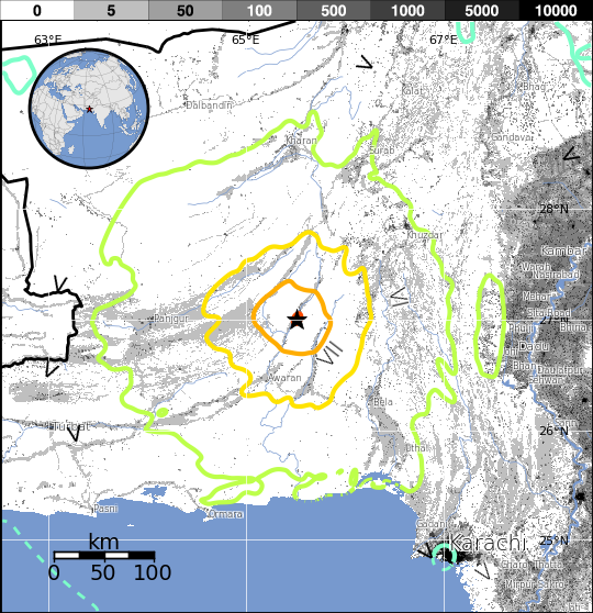
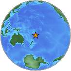
    HONOLULU, Hawaii – A magnitude 7.4 earthquake has struck south of the Fiji Islands, but no Pacific wide tsunami is expected and there is no tsunami threat to Hawaii.


    The Pacific Tsunami Warning Center says based on all available data a destructive tsunami has not been generated.


    The quake happened 106 miles below the ocean, and was actually closest to Vaini, Tonga (174 miles to southwest.)


    The quake was 441 miles southeast of Suva, Fiji.


    According to the United States Geological Survey, the Eastern Margin of the Australia Plate, which stretches from New Zealand to the east of Tonga and Fiji, is highly active.
    From the USGS Tectonic Summary:
    The eastern margin of the Australia plate is one of the most sesimically active areas of the world due to high rates of convergence between the Australia and Pacific plates. In the region of New Zealand, the 3000 km long Australia-Pacific plate boundary extends from south of Macquarie Island to the southern Kermadec Island chain. It includes an oceanic transform (the Macquarie Ridge), two oppositely verging subduction zones (Puysegur and Hikurangi), and a transpressive continental transform, the Alpine Fault through South Island, New Zealand.


    Since 1900 there have been 15 M7.5+ earthquakes recorded near New Zealand. Nine of these, and the four largest, occurred along or near the Macquarie Ridge, including the 1989 M8.2 event on the ridge itself, and the 2004 M8.1 event 200 km to the west of the plate boundary, reflecting intraplate deformation. The largest recorded earthquake in New Zealand itself was the 1931 M7.8 Hawke’s Bay earthquake, which killed 256 people. The last M7.5+ earthquake along the Alpine Fault was 170 years ago; studies of the faults’ strain accumulation suggest that similar events are likely to occur again.


    North of New Zealand, the Australia-Pacific boundary stretches east of Tonga and Fiji to 250 km south of Samoa. For 2,200 km the trench is approximately linear, and includes two segments where old (>120 Myr) Pacific oceanic lithosphere rapidly subducts westward (Kermadec and Tonga). At the northern end of the Tonga trench, the boundary curves sharply westward and changes along a 700 km-long segment from trench-normal subduction, to oblique subduction, to a left lateral transform-like structure.
    Libertatem Prius!


    To view links or images in signatures your post count must be 15 or greater. You currently have 0 posts.


  7. #347
    Creepy Ass Cracka & Site Owner Ryan Ruck's Avatar
    Join Date
    Jul 2005
    Location
    Cincinnati, OH
    Posts
    25,061
    Thanks
    52
    Thanked 78 Times in 76 Posts

    Default Re: Earthquakes, Plate Tectonics and Volcanism


    Impressive Ash Cloud Reaches For The Sky As Japanese Volcano Erupts For The 500th Time This Year

    August 18, 2013

    These ominous pictures show volcanic smoke billowing from one of Japan's most active volcanoes, Mount Sakurajima, captured as its erupted for the 500th time this year.

    At 5000m, this is the highest plume of ash recorded from the mountain since 1955, and caused darkness and ash falls over the centre of nearby Kagoshima city.

    Situated on the southern Japanese main island of Kyushu, the 1,117 metre (3,686 ft) volcano began erupting on the night of August 18, local time.


    The images, taken by the Kagoshima Local Meteorological Observatory, show ash pouring from the volcano's summit.

    Locals living in the shadow of Sakurajima have been urged to cover up and wear masks as a health and safety measure, but there are no immediate reports of injuries.

    Volcanologists believe the mountain may spew out more ash this year than in the previous two decades.

    Masato Iguchi, a professor at the Sakurajima Volcano Research Center, said 2012 saw a record number of eruptions.

    Kyoto University’s disaster reduction research institute keeps close tabs on the volcano in order to avoid a repeat of its 1914 eruption, in which 58 people died.

    That episode was the most powerful volcanic eruption to hit Japan in a hundred years.

    At present, Sakurajima erupts on a small scale several thousand times a year, sending ash a few kilometres above its peak.


  8. #348
    Creepy Ass Cracka & Site Owner Ryan Ruck's Avatar
    Join Date
    Jul 2005
    Location
    Cincinnati, OH
    Posts
    25,061
    Thanks
    52
    Thanked 78 Times in 76 Posts

    Default Re: Earthquakes, Plate Tectonics and Volcanism


    Volcanic 'Geyser' Erupts Close To Rome Airport

    August 25, 2013


    The crater measured about six feet wide and three feet deep

    Motorists on Saturday were alarmed to notice hot, stinking gas spurting from a newly formed crater in the middle of a roundabout close to the perimeter fence of Rome’s Fiumicino airport -- less than 900 yards from the end of a runway.

    Spectators gathered around the smoking crater, which measured about six feet wide and three feet deep, before firefighters and vulcanologists arrived to seal off the roundabout to prevent inhalation of the gas, suspected to be a cocktail of carbon dioxide, hydrogen sulphide and methane. Tests are now underway.

    While initial reports suggested the gas came from rotting organic matter trapped underground, one expert said volcanic activity was more likely.

    “From Mount Etna in Sicily up to the Alban hills around Rome there is a good deal of underground volcanic activity,” Alberto Basili, a seismologist at the Italian National Institute for Geophysics and Vulcanology, told the Daily Telegraph.

    The area covers Mount Vesuvius, which buried the Roman city of Pompeii when it erupted in 79AD, to a number of lakes formed in extinct volcanoes north of Rome.

    “Gas underground can remain hot for tens of thousands of years after volcanoes erupt, and every now and then it can rise to the surface from miles underground,” said Mr Basili.

    “We have seen things like this elsewhere around Rome, with farm animals being killed after they breath in the gas,” he said.

    Despite being a stone’s throw from the end of a main runway at Fiumicino, Europe’s sixth largest airport, which handles 37 million passengers a year, Mr Basili said there was no cause for fear over flight safety. “This is a limited phenomenon – it will not have created alarm at the airport,” he said.


    Here's some video of it:

  9. #349
    Expatriate American Patriot's Avatar
    Join Date
    Jul 2005
    Location
    A Banana Republic, Central America
    Posts
    48,612
    Thanks
    82
    Thanked 28 Times in 28 Posts

    Default Re: Earthquakes, Plate Tectonics and Volcanism

    Weird.

    Shape of things to come?

    LOL

    Rome's second fall

  10. #350
    Literary Wanderer
    Join Date
    Jun 2006
    Location
    Colorado
    Posts
    1,590
    Thanks
    5
    Thanked 6 Times in 6 Posts

    Default Re: Earthquakes, Plate Tectonics and Volcanism

    Let's hope Yellowstone doesn't become active.

  11. #351
    Expatriate American Patriot's Avatar
    Join Date
    Jul 2005
    Location
    A Banana Republic, Central America
    Posts
    48,612
    Thanks
    82
    Thanked 28 Times in 28 Posts

    Default Re: Earthquakes, Plate Tectonics and Volcanism

    You know, MM, if Yellowstone DOES blow it will be just about like having a nuclear war in the US.

    Pretty much anything within about 400 miles of ground zero will probably be killed off. I'm thinking part of the die off a few thousand years ago was directly related to Yellowstone, things like mammoths, sabre-tooth tigers, cave bears and some of the other larger creatures that roamed the North American wilderness.

    The cave bear (Ursus spelaeus) was a species of bear that lived in Europe during the Pleistocene and became extinct at the beginning of the Last Glacial Maximum, about 27,500 years ago.

    A mammoth is any species of the extinct genus Mammuthus, proboscideans commonly equipped with long, curved tusks and, in northern species, a covering of long hair. They lived from the Pliocene epoch (from around 5 million years ago) into the Holocene at about 4,500 years ago[1][2] in Africa, Europe, Asia, and North America.

    A saber-toothed cat (alternatively spelled sabre-toothed cat),[1] also mistakenly known as a saber-toothed tiger,[2][3] is any of various groups of predatory mammals related to modern cats (or resembling cats) that were characterized by long, sabre-shaped canine teeth. These animals belonged to subfamilies of Machairodontinae (Felidae), Barbourofelidae and Nimravidae (both Feliformia) as well as two families related to marsupials that were found worldwide from the Eocene Epoch to the end of the Pleistocene Epoch (42 mya—11,000 years ago), existing for approximately 42 million years

    Obviously all of that is from the wikipedia, and obviously the "dates" are slightly different.

    We really do NOT know how long these creatures lived, when the last one died, or how they died off. We do know that the last eruption of Yellowstone was around 640,000 years ago.

    I'm not saying that there is any certainty that Yellowstone's last eruption DID kill those particular critters off, but the chances are very high we also don't know the precise time Yellowstone blew up, we don't know precisely when the last of those big creatures died, and we aren't 100% sure of what other animals might have been still living around North America when it blew up in the first place.

    But I'd almost bet money on the fact that when Yellowstone goes we will have millions of deaths within a few hundred miles due to ash fallout, rather like Vesuvius and Pompeii. East of Ground Zero there will be deaths related to complete and utter breakdown of America, bad weather, famine and cold. And for a few years, if not hundreds of years, the entire planet will fall into a major cold snap killing most farming, domestic animals and many people.

  12. #352
    Literary Wanderer
    Join Date
    Jun 2006
    Location
    Colorado
    Posts
    1,590
    Thanks
    5
    Thanked 6 Times in 6 Posts

    Default Re: Earthquakes, Plate Tectonics and Volcanism

    I have my doubts regarding the accuracy of info coming to us from any scientific source. Especially regarding such a potentially cataclysmic event. Anyway, such articles shed a little light on the issue...

    http://www.theblaze.com/stories/2011...on-catastophe/

    Is America Headed for Yellowstone Super-Volcano Eruption Catastrophe?

    It would explode with a force a thousand times more powerful than the Mount St Helens eruption in 1980,” the UK’s Daily Mail warns. The world’s largest super-volcano located underneath the United States’ Yellowstone National Park is set to blow.

    Name:  YellowstoneCaldera.jpg
Views: 8
Size:  146.8 KB

    Spewing lava far into the sky, a cloud of plant-killing ash would fan out and dump a layer 10ft deep up to 1,000 miles away.

    Two-thirds of the U.S. could become uninhabitable as toxic air sweeps through it, grounding thousands of flights and forcing millions to leave their homes.

    This is the nightmare that scientists are predicting could happen if the world’s largest super-volcano erupts for the first time in 600,000 years, as it could do in the near future.

    Yellowstone National Park’s caldera has erupted three times in the last 2.1 million years and researchers monitoring it say we could be in for another eruption.

    Scientists have reportedly watched as the super-volcano situated underneath northwestern Wyoming rose at a record rate from 2004-2008 — an average of three inches every year. This rate of movement is more than three times greater than ever observed since such measurement records began in 1923.

    Since 2008, the rate has slowed significantly,and the U.S. Geological Survey says there is “no evidence that another such cataclysmic eruption will occur at Yellowstone in the foreseeable future.”


    But recurrence intervals are neither regular nor predictable and a lack of data has kept geologists from putting any exact date on any potential eruption warning.
    When the eruption finally happens it will dwarf the effect of Iceland’s Eyjafjallajökull volcano, which erupted in April last year, causing travel chaos around the world. …
    Robert B. Smith, professor of geophysics at the University of Utah, who has led a recent study into the volcano, added: ‘Our best evidence is that the crustal magma chamber is filling with molten rock.

    ‘But we have no idea how long this process goes on before there either is an eruption or the inflow of molten rock stops and the caldera deflates again’.

    The Yellowstone Caldera — or “cooking pot” — sits atop North America’s largest volcanic field. The most recent large blast from the Caldera happened an estimated 640,000 years ago and the most recent small eruption happened about 70,000 years ago.

    Name:  Caldera Eruption.jpg
Views: 8
Size:  118.1 KB
    The estimated area of ashfall from the Yellowstone Caldera's last large eruption.

    ‘Clearly some deep source of magma feeds Yellowstone, and since Yellowstone has erupted in the recent geological past, we know that there is magma at shallower depths too,’ said Dan Dzurisin, a Yellowstone expert with the U.S. Geological Survey at Cascades Volcano Observatory in Washington State.

    ‘There has to be magma in the crust, or we wouldn’t have all the hydrothermal activity that we have.

    ‘There is so much heat coming out of Yellowstone right now that if it wasn’t being reheated by magma, the whole system would have gone stone cold since the time of the last eruption 70,000 years ago.’

  13. #353
    Super Moderator Malsua's Avatar
    Join Date
    Jul 2005
    Posts
    8,020
    Thanks
    2
    Thanked 19 Times in 18 Posts

    Default Re: Earthquakes, Plate Tectonics and Volcanism

    Quote Originally Posted by American Patriot View Post
    the entire planet will fall into a major cold snap killing most farming, domestic animals and many people.
    I.E, liberal utopia.
    "Far better it is to dare mighty things, to win glorious triumphs even though checkered by failure, than to rank with those poor spirits who neither enjoy nor suffer much because they live in the gray twilight that knows neither victory nor defeat."
    -- Theodore Roosevelt


  14. #354
    Expatriate American Patriot's Avatar
    Join Date
    Jul 2005
    Location
    A Banana Republic, Central America
    Posts
    48,612
    Thanks
    82
    Thanked 28 Times in 28 Posts

    Default Re: Earthquakes, Plate Tectonics and Volcanism

    LOL@Mal.

    Yeah, true. Kill all the people. They will cry over the animals though. If they were here.

  15. #355
    Expatriate American Patriot's Avatar
    Join Date
    Jul 2005
    Location
    A Banana Republic, Central America
    Posts
    48,612
    Thanks
    82
    Thanked 28 Times in 28 Posts

    Default Re: Earthquakes, Plate Tectonics and Volcanism

    7.7 magnitude earthquake creates new island off the coast of Pakistan- death toll likely to rise

    Posted on September 24, 2013 by The Extinction Protocol


    Earthchange event: The 7.7 magnitude oblique-strike-slip earthquake was so powerful, it raised new land out of the Arabian sea.

    September 24, 2013 – PAKISTAN - A massive, 7.7 magnitude earthquake struck south-central Pakistan on Tuesday afternoon local time. The USGS warns that there will high casualties and economic losses, requiring international response. Seismologists have also confirmed that the quake raised a new island, about 30-40 feet high, off the coast. The island is about half a mile off the coast of Gwadar, in the Arabian Sea. Already, reports the International Herald Tribune, crowds have gathered to see the mountainous, rocky island. Some are claiming it is 100 feet high. It’s not unusual for earthquakes of this magnitude to change the coastline, or even deform the shape of the planet. In 2010, an 8.8 magnitude quake in Chile created new coastlines in that country and changed the shape of the Earth enough to shorten our days by a fraction of a second. Today in Pakistan, estimates of damages are still coming in, and it may be days before we know the full extent of the losses because the quake struck in many regions that are remote. The nearest city to the epicenter is Arawan, where damage is said to be extensive, with houses collapsing and people trapped inside. So far, death tolls hover around 40, but that number is expected to rise as emergency services reach more of the affected areas. The populations near the epicenter may be sparse, but according to the USGS, the problem is that they are extremely vulnerable.

    Most homes are made of materials like unreinforced brick masonry, which crumble quickly in quakes and can be deadly. Karachi is another nearby city, with millions of residents, whose homes may have also been affected. People as far away as New Delhi report feeling the quake. The USGS also offers a quick scientific summary of the nature of the quake: The September 24, 2013 M7.7 earthquake in south-central Pakistan occurred as the result of oblique-strike-slip type motion at shallow crustal depths. The location and mechanism of the earthquake are consistent with rupture within the Eurasia plate above the Makran subduction zone. The event occurred within the transition zone between northward subduction of the Arabia plate beneath the Eurasia plate and northward collision of the India plate with the Eurasia plate. The epicenter of the event is 69km north of Awaran, Pakistan, and 270km north of Karachi, Pakistan (population 11.6 million). Right now, as emergency groups gather more information, the best thing we can do is wait to find out more. But it’s very likely that humanitarian aid will be needed, and as soon as we know more we’ll offer an update. –I09


  16. #356
    Expatriate American Patriot's Avatar
    Join Date
    Jul 2005
    Location
    A Banana Republic, Central America
    Posts
    48,612
    Thanks
    82
    Thanked 28 Times in 28 Posts

    Default Re: Earthquakes, Plate Tectonics and Volcanism


    Estimated Fatalities


    Red alert level for shaking-related fatalities. High casualties are probable and the disaster is likely widespread. Past events with this alert level have required a national or international level response.

    Estimated Economic Losses


    Orange alert level for economic losses. Significant damage is likely. Estimated economic losses are less than 1% of GDP of Pakistan.

  17. #357
    Expatriate American Patriot's Avatar
    Join Date
    Jul 2005
    Location
    A Banana Republic, Central America
    Posts
    48,612
    Thanks
    82
    Thanked 28 Times in 28 Posts

    Default Re: Earthquakes, Plate Tectonics and Volcanism

    So Yellowstone acts up, then Pakistan. Vast distances separate the two - and they are on different plates. But I suspect as one plate moves into another that will trigger stuff on the far side of the secondary plate, etc.

    Just a thought.

  18. #358
    Expatriate American Patriot's Avatar
    Join Date
    Jul 2005
    Location
    A Banana Republic, Central America
    Posts
    48,612
    Thanks
    82
    Thanked 28 Times in 28 Posts

    Default Re: Earthquakes, Plate Tectonics and Volcanism

    Quake kills 45 in Pakistan, creates new island in sea

    By Gul Yusufzai

    QUETTA, Pakistan | Tue Sep 24, 2013 12:21pm EDT


    (Reuters) - A major earthquake hit a remote part of western Pakistan on Tuesday, killing at least 45 people and prompting a new island to rise from the sea just off the country's southern coast.


    Tremors were felt as far away as the Indian capital of New Delhi, hundreds of miles (kilometers) to the east, where buildings shook, as well as the sprawling port city of Karachi in Pakistan.


    The United States Geological Survey said the 7.8 magnitude quake struck 145 miles southeast of Dalbandin in Pakistan's quake-prone province of Baluchistan, which borders Iran.


    The earthquake was so powerful that it caused the seabed to rise and create a small, mountain-like island about 600 meters (yards) off Pakistan's Gwadar coastline in the Arabian Sea.


    Television channels showed images of a stretch of rocky terrain rising above the sea level, with a crowd of bewildered people gathering on the shore to witness the rare phenomenon.


    Officials said scores of mud houses were destroyed by aftershocks in the thinly populated mountainous area near the quake epicenter in Baluchistan, a huge barren province of deserts and rugged mountains.


    Abdul Qadoos, deputy speaker of the Baluchistan assembly, told Reuters that at least 30 percent of houses in the impoverished Awaran district had caved in.


    The local deputy commissioner in Awaran, Abdul Rasheed Gogazai, and the spokesman of Pakistan's Frontier Corps involved in the rescue effort said at least 45 people had been killed.


    In the regional capital of Quetta, officials said some areas appeared to be badly damaged but it was hard to assess the impact quickly because the locations were so remote.


    Chief secretary Babar Yaqoob said earlier that 25 people had been injured and that the death toll was expected to increase as many people appeared to be trapped inside their collapsed homes.


    Local television reported that helicopters carrying relief supplies had been dispatched to the affected area. The army said it had deployed 200 troops to help deal with the disaster.

  19. #359
    Literary Wanderer
    Join Date
    Jun 2006
    Location
    Colorado
    Posts
    1,590
    Thanks
    5
    Thanked 6 Times in 6 Posts

    Default Re: Earthquakes, Plate Tectonics and Volcanism

    Newton's Third Law. I wonder if it applies to plate tectonics?

    Third law: When one body exerts a force on a second body, the second body simultaneously exerts a force equal in magnitude and opposite in direction to that of the first body.

    So, applying this to earthquake activity, if there was a major force generating movement at the earth's surface, would the force be redirected to the other side of the earth to affect tectonic activity opposite the first? With some refraction, perhaps through mantle and core.

    Pakistan is sort of on the other side of the globe from Yellowstone.
    Last edited by MinutemanCO; September 24th, 2013 at 18:52.

  20. #360
    Expatriate American Patriot's Avatar
    Join Date
    Jul 2005
    Location
    A Banana Republic, Central America
    Posts
    48,612
    Thanks
    82
    Thanked 28 Times in 28 Posts

    Default Re: Earthquakes, Plate Tectonics and Volcanism

    Not sure about that in this case.

    Certainly in space if one rock careens off another, and a third is hit by the second the energy imparted by the first to the second, and then the third - but some of it will obviously be lost to other forces in physics - like friction and gravitational pull from the other nearby bodies.

    On the planet, the plates ride on top of oceans of molten magma (supposedly) and gravity strongly affects the mass of each plate pulling it downward as well. So I think the "friction" and "gravity" thing will be much, much stronger on the planet itself.

    So.... with that said the amount of energy transferred to the other side of the plate will be insignificant compared to the original force.

    On the other hand... I have no idea. LOL

Thread Information

Users Browsing this Thread

There are currently 1 users browsing this thread. (0 members and 1 guests)

Bookmarks

Posting Permissions

  • You may not post new threads
  • You may not post replies
  • You may not post attachments
  • You may not edit your posts
  •