Page 21 of 25 FirstFirst ... 11171819202122232425 LastLast
Results 401 to 420 of 495

Thread: Earthquakes, Plate Tectonics and Volcanism

  1. #401
    Expatriate American Patriot's Avatar
    Join Date
    Jul 2005
    Location
    A Banana Republic, Central America
    Posts
    48,612
    Thanks
    82
    Thanked 28 Times in 28 Posts

    Default Re: Earthquakes, Plate Tectonics and Volcanism

    It really IS all about money isn't it?

    Honestly, today I think that a lot of the public is misinformed, but a good portion are not and do know a lot about science.

    This Yellowstone thing though, this is about money now.

    Come on, Seriously, you don't want people to be scared off from something that might actually happen but prefer to make money. LOL


    Yellowstone fighting online supervolcano rumors


    By Associated Press, Updated: Friday, April 4, 11:11 AM


    YELLOWSTONE NATIONAL PARK, Wyo. — Yellowstone National Park is fighting online rumors that running bison seen in a YouTube video are fleeing a possible explosion of the park’s supervolcano.

    The video was posted on March 20, 10 days before a magnitude-4.8 earthquake hit, the park’s strongest quake in 30 years.

    Yellowstone posted a video of its own this week, noting that it’s normal for wildlife to move around to find food at lower elevations that isn’t covered by snow at this time of year. Park spokesman Al Nash says there are no signs to suggest that the volcano is about to erupt.

    Although the YouTube video says the animals are leaving, park spokesman Dan Hottle told the Jackson Hole Daily (http://bit.ly/1hcK4VV) that they are actually running toward the park’s interior and the volcano.
    Last edited by American Patriot; April 4th, 2014 at 18:30.
    Libertatem Prius!


    To view links or images in signatures your post count must be 15 or greater. You currently have 0 posts.


  2. #402
    Expatriate American Patriot's Avatar
    Join Date
    Jul 2005
    Location
    A Banana Republic, Central America
    Posts
    48,612
    Thanks
    82
    Thanked 28 Times in 28 Posts

    Default Re: Earthquakes, Plate Tectonics and Volcanism

    AH! I missed something originally.

    This video was posted, THEN a quake DID happen.

    How interesting.

    Yellowstone fighting web video that claims volcano will erupt

    • Images


    Bison feed in Yellowstone National Park. (Daniel Mayer, http://creativecommons.org/licenses/by-sa/3.0/deed.en)


    Published: 11:14 am


    Updated: 11:40 am


    YELLOWSTONE NATIONAL PARK, Wyo. (AP) — Yellowstone National Park is trying to fight rumors that have surfaced online, which claim that running bison seen in a YouTube video are fleeing precursors of a possible explosion of the park's supervolcano.


    The video was posted on March 20, 10 days before a moderate magnitude 4.8 earthquake hit at the park, the strongest quake there in 30 years.


    Yellowstone posted a video of its own this week, noting that it's normal for wildlife to move around to find food at lower elevations that isn't covered by snow at this time of year. Park spokesman Al Nash said there are no signs to suggest that the volcano is about to erupt.


    Although the video claims the animals are leaving the park, park officials said they are actually running toward the park's interior and the volcano.
    Libertatem Prius!


    To view links or images in signatures your post count must be 15 or greater. You currently have 0 posts.


  3. #403
    Expatriate American Patriot's Avatar
    Join Date
    Jul 2005
    Location
    A Banana Republic, Central America
    Posts
    48,612
    Thanks
    82
    Thanked 28 Times in 28 Posts

    Default Re: Earthquakes, Plate Tectonics and Volcanism

    And the fact is.....


    TA DA!

    The animals were running into the park.

    It's an annual event they do every year.

    The original person that posted it apparently knew this.

    The rest of the dumb asses that started the hype didn't mention they weren't the posters... lol


    The Very Important Detail About That Video of Bison ‘Running for Their Lives’ Out of Yellowstone

    Jonathon M. Seidl


    This week, a video has been circulating claiming to show a herd of bison “running for their lives” out of Yellowstone National Park. The suggestion has been that the animals are sensing imminent danger associated with a volcano in the area.


    But there’s just one problem: park officials told Reuters that the video actually shows the bison galloping into the park, not out of it.
    Below is what appears to be the most popular version, which includes some alarming claims:


    “It was a spring-like day and they were frisky. Contrary to online reports, it’s a natural occurrence and not the end of the world,” park spokeswoman Amy Bartlett told the outlet.


    In fact, one person who claims to be the person behind the original video (many versions have been posted) of the bison running included a detailed description of where the event occurred, and said it’s actually an annual occurrence:
    March 14, 2014 — This herd of Yellowstone National Park Bison dashes from Mammoth Hot Springs eastward along the roadway and deeper into the park. If the herd matriarch gets the urge to run, she will … and the entire herd will run to keep up.


    I’ve been lucky enough to live and work here year-round in Yellowstone National Park since 2010, and every Spring I am blessed to witness them running … in a celebration of life, in a celebration of the coming richness of the Spring Season … and running for the sheer joy of being able to!
    That man is Leo Leckie, and he was interviewed by the LA Times:
    The spreading anxiety was caused by baseless rumors and deliberate misrepresentations of what those bison were actually doing in the video, according to Leo Leckie, a sales associate of the nonprofit Yellowstone Assn., an educational partner of Yellowstone National Park.


    Leckie ought to know. He shot the video, which lasts 1 minute and 9 seconds and was originally posted March 14 on his Facebook page under the title, “Yellowstone bison on the run for the joy of Spring.”


    “Those bison were running for the sake of running,” Leckie said in an interview Thursday. “There was nothing chasing them. There was no mudslide. They were just running.”


    Added Leckie: “And they were running into the park, not away from it.”
    The park also published a video with a fuller explanation saying that, during the dead of winter, the animals will drop to lower elevations and even wander outside the park in order to find food. When spring returns, they flood back into the park:


    As for volcanic and seismic activity, the official video explains that the area experiences thousands of earthquakes a year, but many of them are very small. But Al Nash, the chief of public affairs at the park, did say that the park experienced its biggest earthquake (4.8) in 30 years on Sunday.


    Still, he says, that’s no cause for worry.


    “We have seen no signs to suggest the Yellowstone volcano is about to erupt,” he said.


    Peter Cervelli, associate director for science and technology at the U.S. Geological Survey’s Volcano Science Center in California and a scientist with the Yellowstone Volcano Observatory, agrees.


    “The chance of that happening in our lifetimes is exceedingly insignificant,” he told Reuters.
    Libertatem Prius!


    To view links or images in signatures your post count must be 15 or greater. You currently have 0 posts.


  4. #404
    Expatriate American Patriot's Avatar
    Join Date
    Jul 2005
    Location
    A Banana Republic, Central America
    Posts
    48,612
    Thanks
    82
    Thanked 28 Times in 28 Posts

    Default Re: Earthquakes, Plate Tectonics and Volcanism

    Scientists dismiss claims that Yellowstone volcano about to erupt


    .View photo

    The Yellowstone River winds through the Hayden Valley in Yellowstone National Park, Wyoming, June 9, …


    By Laura Zuckerman


    (Reuters) - Yellowstone National Park assured guests and the public on Thursday that a super-volcano under the park was not expected to erupt anytime soon, despite an alarmist video that claimed bison had been seen fleeing to avoid such a calamity.


    Yellowstone officials, who fielded dozens of calls and emails since the video went viral this week following an earthquake in the park, said the video actually shows bison galloping down a paved road that leads deeper into the park. (To see the video, click on http://www.youtube.com/watch?v=ij7ZHa1GqPQ)


    "It was a spring-like day and they were frisky. Contrary to online reports, it's a natural occurrence and not the end of the world," park spokeswoman Amy Bartlett said.
    Assurances by Yellowstone officials and government geologists that the ancient super-volcano beneath the park is not due to explode for eons have apparently done little to quell fears among the thousands who have viewed recent video postings of the thundering herd.


    Commentary with one of the clips by a self-described survivalist wearing camouflage, dark sunglasses and a black watch cap suggests the wildlife exodus may be tied to "an imminent eruption here at Yellowstone."


    The 4.8 magnitude earthquake that struck early Sunday near the Norris Geyser Basin in the northwest section of Yellowstone, which spans 3,472 square miles of Wyoming, Montana and Idaho, caused no injuries or damages and did not make any noticeable alterations to the landscape, geologists said.


    Though benign by seismic standards, it was the largest to rattle Yellowstone since a 4.8 quake in February 1980 and it occurred near an area of ground uplift tied to the upward movement of molten rock in the super-volcano, whose mouth, or caldera, is 50 miles long and 30 miles wide.


    But neither the quake, the largest among hundreds that have struck near the geyser basin in the last seven months, nor the uplift suggest an eruption sooner than tens of thousands of years, said Peter Cervelli, associate director for science and technology at the U.S. Geological Survey's Volcano Science Center in California.


    "The chance of that happening in our lifetimes is exceedingly insignificant," said Cervelli, a scientist with the Yellowstone Volcano Observatory.


    Cervelli said the area of uplift that scientists have been tracking since August is rising at a rate of between 10 centimeters (4 inches) and 15 centimeters a year. Geologists who tracked uplift in the same area from 1996 to 2003 also saw elevated seismic activity, he said.
    Libertatem Prius!


    To view links or images in signatures your post count must be 15 or greater. You currently have 0 posts.


  5. #405
    Creepy Ass Cracka & Site Owner Ryan Ruck's Avatar
    Join Date
    Jul 2005
    Location
    Cincinnati, OH
    Posts
    25,061
    Thanks
    52
    Thanked 78 Times in 76 Posts

    Default Re: Earthquakes, Plate Tectonics and Volcanism


    Throat Of Fire Volcano In Ecuador Erupts Explosively

    April 5, 2014

    Tungurahua volcano in Ecuador erupted powerfully and explosively on Friday (April 4, 2014), sending a 6-mile (10-km) column of ash skyward. AP reports that the initial five-minute explosion shot hot gas and rock onto the volcano’s northern and northwestern flanks and that a second, four-minute explosions and five lesser tremors followed.

    According to AP, Ecuador’s geophysics institute said Friday’s blast occurred at 6:10 p.m. local time.

    Tungurahua is from the Quichua word tunguri (throat) and rahua (fire): “Throat of Fire.”


    Tungurahua volcano is an active stratovolcano. This type of volcano is built up by many layers (strata) of hardened lava, tephra, pumice, and volcanic ash. Unlike shield volcanoes, stratovolcanoes are characterized by periodic explosive eruptions and quiet eruptions.

    Tungurahua been erupting periodically since 1999. Its eruptions have been ongoing since 2013, with several major eruptions since then, the last one prior to yesterday’s starting on February 1 of this year. AP reports that the 2014 eruptions of this volcano have affected a third of Ecuador’s provinces and temporarily closed a regional airport.

    In 2006, a pyroclastic cloud from Tungurahua killed four people and left two missing.

  6. #406
    Creepy Ass Cracka & Site Owner Ryan Ruck's Avatar
    Join Date
    Jul 2005
    Location
    Cincinnati, OH
    Posts
    25,061
    Thanks
    52
    Thanked 78 Times in 76 Posts

    Default Re: Earthquakes, Plate Tectonics and Volcanism


    Series Of Small Earthquakes Rock Oklahoma In Record Seismic Activity

    April 6, 2014

    Earthquakes rattled residents in Oklahoma on Saturday, the latest in a series that have put the state on track for record quake activity this year, which some seismologists say may be tied to oil and gas exploration.

    One earthquake recorded at 3.8 magnitude by the U.S. Geological Survey rocked houses in several communities around central Oklahoma at 7:42 a.m. local time. Another about two hours earlier in the same part of the state, north of Oklahoma City, was recorded at 2.9 magnitude, USGS said.

    Those two were preceded by two more, at 2.6 magnitude, and 2.5 magnitude, that also rolled the landscape in central Oklahoma early Saturday morning. A 3.0 magnitude tremor struck late Friday night in that area as well, following a 3.4 magnitude hit Friday afternoon.

    Austin Holland, a seismologist with the Oklahoma Geological Survey who tracks earthquake activity for the USGS, said the earthquake activity in the state is soaring.

    "We have had almost as many magnitude 3 and greater already in 2014 than we did for all of 2013," Holland said.

    Last year's number of "felt" earthquakes - those strong enough to rattle items on a shelf - hit a record 222 in the state. This year, less than four months into the year, the state has recorded 253 such tremors, according to state seismic data.

    "We have already crushed last year's record for number of earthquakes," Holland said.

    Most earthquakes occur naturally. But scientists have long linked some small earthquakes to oil and gas work underground, which can alter pressure points and cause shifts in the earth.

    Oil and gas exploration has increased in recent years across the country, spurred by U.S. efforts for energy independence. Modern hydraulic fracturing, or fracking, is one particularly controversial technique.

    For bigger quakes, so far this year the state has recorded 106 at 3.0 magnitude and above, according to Holland. For all of last year the state had 109 at 3.0 and above.

    In November 2011, Oklahoma suffered a 5.6 magnitude quake that damaged more than a dozen homes and several businesses.

    Wastewater disposal related to the fracking is suspected by many scientists to contribute to the earthquake activity. Millions of gallons of wastewater are typically trucked from a fracking site to wells where the water is injected thousands of feet underground into porous rock layers. That work, if done near a fault, can trigger larger quakes, according to several recent scientific studies.

    Oklahoma recorded 278 earthquakes from 2008 through 2013 that have registered on the Richter scale at a magnitude of 3.0 or greater, a level that can shake objects inside a home.

    Before that, from 1975-2008, the state on average recorded less than six earthquakes a year.

  7. #407
    Expatriate American Patriot's Avatar
    Join Date
    Jul 2005
    Location
    A Banana Republic, Central America
    Posts
    48,612
    Thanks
    82
    Thanked 28 Times in 28 Posts

    Default Re: Earthquakes, Plate Tectonics and Volcanism

    Interesting. Somewhat south of Yellowstone and Grand Teton... but in the mountains there.


    Homes Evacuated in Jackson Wyoming as Ground Shifts
    By Benito Baeza April 11, 2014 7:17 AM


    JACKSON, Wyo. (AP) — Dozens of Jackson, Wyo., residents who were evacuated after land began shifting on a hillside in the resort town are waiting to find out if and when they can return home.

    Assistant Town Manager Roxanne Robinson said Thursday there is still no word what is causing the land to shift, but officials have taken steps to ensure there is no catastrophe. Geologists are on the scene. About two dozen people went to the Red Cross to get shelter. Police say they talked to 52 people, and some evacuees say they were told authorities are not returning until it is safe. Ground movement over the weekend caused water pipes to break at the town’s pump station, and visible fissures have formed in the hillside.


    Read More: Homes Evacuated in Jackson Wyoming as Ground Shifts | http://newsradio1310.com/homes-evacu...ckback=tsmclip
    Libertatem Prius!


    To view links or images in signatures your post count must be 15 or greater. You currently have 0 posts.


  8. #408
    Expatriate American Patriot's Avatar
    Join Date
    Jul 2005
    Location
    A Banana Republic, Central America
    Posts
    48,612
    Thanks
    82
    Thanked 28 Times in 28 Posts

    Default Re: Earthquakes, Plate Tectonics and Volcanism

    Today:

    Globe with Earthquake Location

    M6.1 - NICARAGUA

    Preliminary Earthquake Report
    Magnitude 6.1
    Date-Time
    * 10 Apr 2014 23:27:46 UTC
    * 10 Apr 2014 17:27:47 near epicenter
    * 10 Apr 2014 16:27:46 standard time in your timezone

    Location 12.539N 86.470W
    Depth 10 km
    Distances
    * 18 km (11 mi) SE of Larreynaga, Nicaragua
    * 31 km (19 mi) NNE of Nagarote, Nicaragua
    * 31 km (19 mi) NE of La Paz Centro, Nicaragua
    * 39 km (24 mi) S of El Sauce, Nicaragua
    * 50 km (31 mi) NNW of Managua, Nicaragua

    Location Uncertainty Horizontal: 0.0 km; Vertical 1.8 km
    Parameters Nph = 75; Dmin = 127.9 km; Rmss = 1.91 seconds; Gp = 70°
    Version =
    Event ID us d0003cqx


    Globe with Earthquake Location

    M6.0 - NEAR THE COAST OF TARAPACA, CHILE

    Preliminary Earthquake Report
    Magnitude 6.0
    Date-Time
    * 11 Apr 2014 00:01:44 UTC
    * 10 Apr 2014 19:01:44 near epicenter
    * 10 Apr 2014 17:01:44 standard time in your timezone

    Location 20.748S 70.724W
    Depth 17 km
    Distances
    * 84 km (52 mi) SW of Iquique, Chile
    * 158 km (97 mi) NNW of Tocopilla, Chile
    * 255 km (158 mi) S of Arica, Chile
    * 265 km (164 mi) NW of Calama, Chile
    * 542 km (336 mi) SSW of La Paz, Bolivia

    Location Uncertainty Horizontal: 0.0 km; Vertical 3.9 km
    Parameters Nph = 52; Dmin = 60.3 km; Rmss = 1.32 seconds; Gp = 139°
    Version =
    Event ID us c000pfgr


    Globe with Earthquake Location

    M7.3 - BOUGAINVILLE REGION, PAPUA NEW GUINEA

    Preliminary Earthquake Report
    Magnitude 7.3
    Date-Time
    * 11 Apr 2014 07:07:22 UTC
    * 11 Apr 2014 18:07:22 near epicenter
    * 11 Apr 2014 00:07:22 standard time in your timezone

    Location 6.653S 155.043E
    Depth 50 km
    Distances
    * 61 km (37 mi) SW of Panguna, Papua New Guinea
    * 73 km (45 mi) SW of Arawa, Papua New Guinea
    * 399 km (247 mi) SE of Kokopo, Papua New Guinea
    * 555 km (344 mi) ESE of Kimbe, Papua New Guinea
    * 622 km (385 mi) WNW of Honiara, Solomon Islands

    Location Uncertainty Horizontal: 0.0 km; Vertical 6.3 km
    Parameters Nph = 101; Dmin = 419.2 km; Rmss = 1.14 seconds; Gp = 29°
    Version = 1
    Event ID us c000pft9


    Globe with Earthquake Location

    M6.7 - BOUGAINVILLE REGION, PAPUA NEW GUINEA

    Preliminary Earthquake Report
    Magnitude 6.7
    Date-Time
    * 11 Apr 2014 08:16:49 UTC
    * 11 Apr 2014 18:16:50 near epicenter
    * 11 Apr 2014 01:16:49 standard time in your timezone

    Location 6.835S 154.967E
    Depth 50 km
    Distances
    * 81 km (50 mi) SW of Panguna, Papua New Guinea
    * 93 km (57 mi) SW of Arawa, Papua New Guinea
    * 406 km (251 mi) SE of Kokopo, Papua New Guinea
    * 552 km (342 mi) ESE of Kimbe, Papua New Guinea
    * 619 km (383 mi) WNW of Honiara, Solomon Islands

    Location Uncertainty Horizontal: 0.0 km; Vertical 5.8 km
    Parameters Nph = 91; Dmin = 426.4 km; Rmss = 1.28 seconds; Gp = 29°
    Version = 1
    Event ID us c000pfuy
    Libertatem Prius!


    To view links or images in signatures your post count must be 15 or greater. You currently have 0 posts.


  9. #409
    Expatriate American Patriot's Avatar
    Join Date
    Jul 2005
    Location
    A Banana Republic, Central America
    Posts
    48,612
    Thanks
    82
    Thanked 28 Times in 28 Posts

    Default Re: Earthquakes, Plate Tectonics and Volcanism

    Earthquake near Challis biggest in Idaho since 2005

    Credit: KTVB
    Historic images from the 1983 earthquake in Challis show widespread damage to downtown buildings. In contrast, Thursday's earthquake released 10,000 times less energy.


    by Matt Standal
    Bio | Email | Follow: @KTVBMatt KTVB.COM
    Posted on April 10, 2014 at 7:13 AM
    Updated today at 4:02 AM


    CHALLIS, Idaho -- The U.S. Geological Survey reports a magnitude 4.1 earthquake shook the ground about 9 miles north of Challis at 6:21 a.m. Thursday.


    It's the strongest earthquake reported in Idaho since 2005.


    Custer County Sheriff Stu Lumpkin says no damage or injuries were reported, but 911 callers reported the ground shaking up to 45 miles away.


    "It was a fairly minor event," Lumpkin said. "I've only talked to about three people who have actually felt it, but when I was sitting on the bed putting my boots on, it shook the whole bed and rattled the windows in the house."


    Dispatchers told KTVB reports of shaking ranged from the East Fork of the Salmon River to the Elk Bend area.


    A magnitude 4.1 earthquake is felt by most people in the affected area, causes noticeable shaking and rattling of objects indoors, but typically causes minimal to zero damage.


    Researchers at Boise State University say while Thursday's magnitude 4.1 earthquake was the biggest in nearly a decade, its size and intensity was fairly common.


    That's because 68 earthquakes magnitude 4 or larger have been reported by scientists in Idaho in recorded history. In comparison, only 6 earthquakes magnitude 5 or larger have registered in Idaho.


    The strongest earthquake -- a magnitude 6.9 on the Richter scale -- was measured in 1983 near Borah Peak, and caused widespread damage along with two deaths.


    Boise State University Assistant Professor Jeff Johnson says that's the only earthquake stronger than 6.0 on the Richter scale that's been measured in our state.


    In contrast, Thursday's earthquake released ten-thousand times less energy.


    Johnson says while clusters of earthquakes have lately been reported in eastern Idaho, it's impossible to draw conclusions about the intensity of future earthquakes based upon it.
    See: USGS: Quake shakes Yellowstone, strongest since 1980

    Translation: Thursday's earthquake doesn't necessarily foreshadow a disastrous event, but it doesn't preclude it either.


    "Everything suggests that this is business as usual for this particular part of Idaho," Johnson told KTVB. "These earthquakes are not uncommon, and they will happen into the future."
    Libertatem Prius!


    To view links or images in signatures your post count must be 15 or greater. You currently have 0 posts.


  10. #410
    Expatriate American Patriot's Avatar
    Join Date
    Jul 2005
    Location
    A Banana Republic, Central America
    Posts
    48,612
    Thanks
    82
    Thanked 28 Times in 28 Posts

    Default Re: Earthquakes, Plate Tectonics and Volcanism

    Earthquakes shake central Oklahoma Wednesday and Thursday

    A 4.1 magnitude earthquake was reported in central Oklahoma. The quake happened early Thursday and was one of several in the area.
    FROM STAFF REPORTS • Modified: April 10, 2014 at 5:42 pm • Published: April 10, 2014
    Advertisement


    GUTHRIE — Several earthquakes, including a magnitude-4.1 quake, shook parts of central Oklahoma early Thursday, the U.S. Geological Survey reported.

    The 4.1 quake was felt in parts of southern Logan and northern Oklahoma counties at 2:33 a.m. The epicenter was about six miles south-southwest of Guthrie, about a half mile north of W Forrest Hills Road.
    Social media users in the area reported feeling the quake and being awakened by shaking and loud noises. One woman in south Edmond said the quake “knocked our power off and on for a bit.”
    Austin Holland, seismologist for the Oklahoma Geological Survey in Norman, said the overnight earthquakes were part of the Liberty Lake swarm, which started Feb. 12. Residents have reported hearing booms and some have reported objects falling inside homes. The central Oklahoma earthquakes continue to be studied by scientists, he said.
    “There are a lot of different earthquake sequences going on right now in Logan County,” Holland said.
    Mark Sharpton is the Logan County commissioner for District No. 1, which includes the area where the quakes were reported. Sharpton said the largest earthquake of the night, the magnitude-4.1 quake, woke him up, and he was unable to get back to sleep afterward.
    Libertatem Prius!


    To view links or images in signatures your post count must be 15 or greater. You currently have 0 posts.


  11. #411
    Expatriate American Patriot's Avatar
    Join Date
    Jul 2005
    Location
    A Banana Republic, Central America
    Posts
    48,612
    Thanks
    82
    Thanked 28 Times in 28 Posts

    Default Re: Earthquakes, Plate Tectonics and Volcanism

    Mysterious rumbling along coast wasn't earthquake, experts say


    • Email

      Share
      0


    By Rong-Gong Lin II April 9, 2014, 5:10 p.m.

    This post has been updated. See note below for details.
    Some residents in Long Beach and the north Orange County coast reported feeling and hearing what some thought was an earthquake Wednesday afternoon.
    But Caltech seismologist Kate Hutton said no earthquakes were reported in the area during the time the shaking was reported.


    “It’s not an earthquake. It’s probably an offshore sonic boom,” Hutton said.
    Federal Aviation Administration spokesman Ian Gregor said any sonic boom would come from a military aircraft.
    "Civil aircraft do not exceed the speed of sound, so any sonic boom would come from a military aircraft," he said. "Military aircraft do not fly supersonically in civilian airspace; they would only do so in restricted military airspace out over the ocean."
    [Updated at 5:09 p.m. PST, April 9:
    The rumbling appears to have actually been caused by a supersonic Navy flight.
    The U.S. Navy confirmed an aircraft flew faster than the speed of sound as part of an exercise with the USS Ronald Reagan aircraft carrier about 50 miles off the coast this afternoon.
    The sonic boom at around 1 p.m. was felt across a wide area, from Malibu to Orange County. Many assumed it was an earthquake, but Caltech seismologists said they did not record any earth movement.
    Navy Cmdr. Kevin Stephens noted that when the Navy conducted a similar flight further south in the summer of 2012, "pretty much all of San Diego felt it."
    Scott Conner, who lives in the Big Rock neighborhood of Malibu, said he was convinced the shaking he felt just after 1 p.m. was a quake.
    He said the shaking was so intense one of his computer monitors would’ve tipped over if he wasn’t there to steady it.
    “I had to put out my hand to keep it from tipping over,” Conner said in a telephone interview.
    “I thought it was the biggest quake I’ve ever been in…. This thing was big, big,” he said. “The whole house just lifted.
    “I’ve been around air force bases. I know what sonic booms are. There was no boom, either,” Conner said.]
    Libertatem Prius!


    To view links or images in signatures your post count must be 15 or greater. You currently have 0 posts.


  12. #412
    Expatriate American Patriot's Avatar
    Join Date
    Jul 2005
    Location
    A Banana Republic, Central America
    Posts
    48,612
    Thanks
    82
    Thanked 28 Times in 28 Posts

    Default Re: Earthquakes, Plate Tectonics and Volcanism

    Explainer: Strong Quakes Rock Yellowstone


    31 March 2014 3:30 pm


    2 Comments
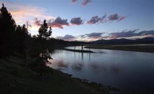
    Shaker. On Sunday, 30 March, a magnitude-4.8 quake struck near Yellowstone National Park's Norris Geyser Basin (shown).


    On Sunday morning, 30 March, a magnitude-4.8 quake struck Yellowstone National Park, centered about 6.4 kilometers northeast of the park’s iconic Norris Geyser Basin. That temblor, the largest to strike the park since 1980, is part of a series of at least 25 quakes that began in the area on Thursday, 27 March. Besides the main shock, the largest quake in this group measured magnitude 3.3.


    Is such seismic activity normal?

    Yes. There have been three clusters, or swarms, of earthquakes beneath Yellowstone in the past 6 months, says Robert Smith, a geophysicist at the University of Utah in Salt Lake City. Sunday’s quake is notable only because it’s somewhat larger than recent temblors. On average, the park experiences about 3000 quakes per year, he notes: “Yellowstone never stops shaking.”


    What caused the quakes?
    In general, the presence and movement of molten material at shallow and intermediate depths beneath Yellowstone is what triggers much of the seismic activity there. (The heat from that molten rock, of course, is the driving force for the park’s iconic geysers.) Sunday’s magnitude-4.8 quake was centered in a region where instruments have measured the landscape rising and falling for the past several months. That connection, too, is normal: A previous period of uplift in the same area between 1996 and 2003 was also accompanied by increased seismic activity. Nevertheless, Smith says, the causes of specific quakes and swarms are difficult to pin down. There have been spates of quakes without uplift, and there have been extended periods of uplift without abnormally high seismic activity.


    Are these quakes related to those in southern California?
    Probably not. Although it’s possible for a quake in one area to trigger others along faults in a distant region, the Yellowstone quakes are much more likely to be related to geological changes taking place locally within Earth’s crust.


    Do the Yellowstone quakes pose a future threat?
    Unlikely. There’s no sign that the current swarm of quakes is any different from those experienced there in recent months or years, and it doesn’t seem to be linked to any volcanic processes, he notes.


    What’s next?
    A field team from the U.S. Geological Survey arrived in Yellowstone on Sunday. They’re assessing the area near the quake’s epicenter to see if the event altered the terrain, and they’ll also check to see if the seismic activity has changed the size or eruption frequency of geysers in the area.
    Libertatem Prius!


    To view links or images in signatures your post count must be 15 or greater. You currently have 0 posts.


  13. #413
    Expatriate American Patriot's Avatar
    Join Date
    Jul 2005
    Location
    A Banana Republic, Central America
    Posts
    48,612
    Thanks
    82
    Thanked 28 Times in 28 Posts

    Default Re: Earthquakes, Plate Tectonics and Volcanism

    Yellowstone earthquake gets no notice despite size


    Print
    Font Size:
    Default font size
    Larger font size

    Tweet

    ?

    Posted: Monday, March 31, 2014 4:30 am
    By Mark Huffman Jackson Hole Daily | 0 comments
    If the earth shakes in the forest and there’s no one there, is it really an earthquake?
    The United States Geological Survey says yes, even though the series of quakes that hit Yellowstone National Park early Sunday was witnessed, apparently, by nothing on two legs.


    The quakes all hit about 4 miles northeast of Norris Geyser Basin, and were known only through the efficiency of automatic monitoring devices. The biggest, a 4.8 shake, was pronounced the strongest temblor in the park since Feb. 22, 1980.

    But that quake, though notable, went unnoticed where it actually happened.

    “I talked to someone at Mammoth and they didn’t feel the largest quake,” said Yellowstone park spokesman Al Nash. As for the actual quake location, “we just don’t have anybody there right now.

    “There are people working to clear roads, but we don’t have anyone staffing or living at the Norris this time of year,” he said.

    The 4.8 hit at 6:34 a.m., according to University of Utah seismograph stations in the area. More than 25 smaller shakes were recorded starting on Thursday, including two of 2.8 and 3.0 soon after midnight Sunday and another four in the hours after the 4.8. The second largest was a 3.3 monitored at 9:12 a.m.

    The depth of Sunday’s quakes ranged from 1 to 4.8 miles.

    A University of Utah release said that the quake area had experienced a “ground uplift” since August and that “seismicity in the general region of the uplift has been elevated for several months.”

    The USGS planned to send a team to the area Sunday to look for any sign of the earthquakes, including any effects to the geysers and hot pools at Norris.
    Libertatem Prius!


    To view links or images in signatures your post count must be 15 or greater. You currently have 0 posts.


  14. #414
    Expatriate American Patriot's Avatar
    Join Date
    Jul 2005
    Location
    A Banana Republic, Central America
    Posts
    48,612
    Thanks
    82
    Thanked 28 Times in 28 Posts

    Default Re: Earthquakes, Plate Tectonics and Volcanism

    Rare Earthquake Warning Issued for Oklahoma

    By Becky Oskin, Senior Writer | May 05, 2014 03:30pm ET


    Mile for mile, there are almost as many earthquakes rattling Oklahoma as California this year. This major increase in seismic shaking led to a rare earthquake warning today (May 5) from the U.S. Geological Survey and the Oklahoma Geological Survey.

    In a joint statement, the agencies said the risk of a damaging earthquake — one larger than magnitude 5.0 — has significantly increased in central Oklahoma.


    Geologists don't know when or where the state's next big earthquake will strike, nor will they put a number on the increased risk. "We haven't seen this before in Oklahoma, so we had some concerns about putting a specific number on the chances of it," Robert Williams, a research geophysicist with the USGS Earthquake Hazards Program in Golden, Colorado, told Live Science. "But we know from other cases around the world that if you have an increasing number of small earthquakes, the chances of a larger one will go up." [Watch 2500+ Oklahoma Earthquakes Since 2012 (Video)]


    That's why earthquakes of magnitude 5 and larger are more frequent in states such as California and Alaska, where thousands of smaller temblors hit every year.


    This is the first time the USGS has issued an earthquake warning for a state east of the Rockies, Williams said. Such seismic hazard assessments are more typically issued for Western states following large quakes, to warn residents of the risk of damaging aftershocks, he said.


    The geological agencies took action after the rate of earthquakes in Oklahoma outpaced that of even California for the first few months of 2014. (California regained the lead in April.) [The 10 Biggest Earthquakes in History]


    "The rate of earthquakes increased dramatically in March and April," Williams said. "That alerted us to examine this further and put out this advisory statement."
    While Oklahoma's buildings can withstand light earthquakes, the damage from a magnitude-5 temblor could be widespread. Oklahoma's last major earthquake was in November 2011, when a magnitude-5.6 earthquake centered near Prague, Oklahoma, destroyed 14 homes and injured at least two people.


    "Building owners and government officials should have a special concern for older, unreinforced brick structures, which are vulnerable to serious damage during sufficient shaking," Bill Leith, a USGS senior science adviser for earthquakes and geologic hazards, said in the joint statement.


    While scientists haven't ruled out natural causes for the increase, many researchers suspect the deep injection wells used for the disposal of fracking wastewater could be causing the earthquake activity. Fracking, short for hydraulic fracturing, is a method of extracting oil and gas by cracking open underground rock.


    Oklahoma earthquakes.

    Credit: USGSView full size image


    Ongoing studies have found a link between Oklahoma's high-volume wastewater injection wells and regions with an uptick in earthquakes.


    According to the USGS, the number of quakes magnitude-3 and stronger jumped by 50 percent in the past eight months in Oklahoma. Some 183 earthquakes of magnitude 3 or greater struck between October 2013 and April 14, 2014. The state's long-term average from 1978 to 2008 was only two earthquakes of magnitude 3.0 or larger per year.


    If the earthquakes are caused by wastewater injection, then the activity could continue or decrease with future changes in well usage in the state.


    "We don't know if this earthquake rate is going to continue," Williams said. "It could go to a higher rate or lower, so the increased chances of a damaging quake could change in the future."
    Libertatem Prius!


    To view links or images in signatures your post count must be 15 or greater. You currently have 0 posts.


  15. #415
    Creepy Ass Cracka & Site Owner Ryan Ruck's Avatar
    Join Date
    Jul 2005
    Location
    Cincinnati, OH
    Posts
    25,061
    Thanks
    52
    Thanked 78 Times in 76 Posts

    Default Re: Earthquakes, Plate Tectonics and Volcanism

    Fun Fact: This day in 1980 Mount St. Helens erupted.

  16. #416
    Expatriate American Patriot's Avatar
    Join Date
    Jul 2005
    Location
    A Banana Republic, Central America
    Posts
    48,612
    Thanks
    82
    Thanked 28 Times in 28 Posts

    Default Re: Earthquakes, Plate Tectonics and Volcanism

    cough cough cough....

    lol

    (I remember that tomorrow it will be dusty in Oklahoma - among other places)
    Libertatem Prius!


    To view links or images in signatures your post count must be 15 or greater. You currently have 0 posts.


  17. #417
    Expatriate American Patriot's Avatar
    Join Date
    Jul 2005
    Location
    A Banana Republic, Central America
    Posts
    48,612
    Thanks
    82
    Thanked 28 Times in 28 Posts

    Default Re: Earthquakes, Plate Tectonics and Volcanism

    Pavlof Eruption Status Raised: Are There Risks to Aviation?

    June 3, 2014 by Jennifer Young Leave a Comment
    Tweet


    The June 2 2014 eruption of Pavlof volcano. Image credit: Christoper Diaz, northernXposed Photography

    This week in the south-west Pacific, an ash cloud rising from Indonesia’s erupting Sangeang Api volcano has resulted in the cancellation of flights over northern Australia, and in the north-east of the same ocean, the threat of a major eruption hangs over Alaska’s Pavlof volcano.
    Pavlof Alert in Alaska

    On June 2, the United States Geological Survey raised the alert for Pavlof to the highest level.


    The alert, which is in two parts, consists of a volcano alert level, currently set at ‘warning’ – indicating that “hazardous eruption is imminent, underway, or suspected” – and an aviation colour code, currently set at red – which means that “Eruption is imminent with significant emission of volcanic ash into the atmosphere likely OR eruption is underway or suspected with significant emission of volcanic ash into the atmosphere [ash-plume height specified, if possible].”

    Although Pavlof last erupted as recently as June 2013, the alert level was reduced to green in August of that year and remained at that level until 31 May 2014, when it was raised to amber (the second highest) following a low-level eruption. The escalation of this eruption led to the increased alert and concerns about possible hazards to aviation.

    Pavlof and the Aleutian Chain

    Pavlof is part of the Aleutian volcanic arc. Image credit: USGS


    Pavlof is just one of almost 100 active or recently-active volcanoes in Alaska, most of them forming the Aleutian island chain which runs in an arc along the Alaskan subduction zone.


    Part of the so-called Pacific Ring of Fire, this line of volcanoes results from the downwards movement of the dense Pacific plate as it meets the North American plate.


    The ocean crust melts as it descends to great depths in the mantle. The molten rock, more buoyant than the overlying rock, rises and reaches the surface as lava – and creates a chain of volcanoes behind the actual plate margin. The Aleutian islands are a classic example of such a a volcanic arc.


    Eruptions are by no means uncommon and at the time of writing three other Alaskan volcanoes are under either amber or yellow watch. Pavlof itself has been regularly active; the GVP database includes 21 confirmed eruptions since 1950, several of them erupting large volumes of lava and lasting for anything from one day to several months.
    Ash Clouds and Aviation Hazard

    Volcanic alerts are at two levels. Image credit: USGS


    Despite the levels of volcanic activity (according to the Smithsonian Institution’s Global Volcanism Program “only Indonesia, Japan, and South America have had more volcanoes erupt during the past 100 years”) past eruptions have had limited impact on humans.


    Most of the islands are uninhabited and so the degree of hazard is very low. Indeed, again according to the GVP, fatalities have been recorded from only three Alaskan eruptions.


    Times are changing – and an eruption in an uninhabited part of the north Pacific will no longer go unnoticed. In a modern, increasingly digital, age, even remote volcanoes have an increased level of hazard.


    The 2010 eruption of Iceland’s Eyjafjallajokull, which closed large parts of European airspace for days with consequent travel disruption and economic losses, raised awareness of the vulnerability of air traffic to volcanic ash and extended the understanding of a volcanic hazard well beyond the immediate surroundings.


    Ash is a problem for aviation not just because it can impair visibility, but because the fine, abrasive particles can be sucked into jet engines and, melting, cause them to become clogged and to stall. Although to date there are no known cases in which volcanic ash has brought an aircraft down, there are several documented incidents of engines stalling and disaster narrowly averted.


    For this reason, aviation authorities sit up and take notice when a major eruption occurs – and Alaska is overflown by many commercial flights between the US and parts of Asia, meaning that these remote volcanoes are increasingly monitored.
    Pavlof’s Aviation Hazard

    At present there is no expected disruption associated with Pavlof, despite reports that its plume has reached heights of around 22,000 feet. The current aviation advisory indicates reduced visibility and light ash fall in the immediate vicinity of the volcano. But if the eruption continues or strengthens, and depending on atmospheric conditions, the situation may change – and a few more people may start to notice what’s happening way up north.
    Libertatem Prius!


    To view links or images in signatures your post count must be 15 or greater. You currently have 0 posts.


  18. #418
    Creepy Ass Cracka & Site Owner Ryan Ruck's Avatar
    Join Date
    Jul 2005
    Location
    Cincinnati, OH
    Posts
    25,061
    Thanks
    52
    Thanked 78 Times in 76 Posts

    Default Re: Earthquakes, Plate Tectonics and Volcanism

    Quote Originally Posted by American Patriot View Post
    Proof the Illuminati control the volcanoes!


  19. #419
    Creepy Ass Cracka & Site Owner Ryan Ruck's Avatar
    Join Date
    Jul 2005
    Location
    Cincinnati, OH
    Posts
    25,061
    Thanks
    52
    Thanked 78 Times in 76 Posts

    Default Re: Earthquakes, Plate Tectonics and Volcanism


    L.A. Quakes Are increasing, But Scientists Aren't Sure What It Means

    June 2, 2014

    No, it's not your imagination: The Los Angeles area is feeling more earthquakes this year.

    After a relatively quiet period of seismic activity in the Los Angeles area, the last five months have been marked by five earthquakes larger than 4.0. That hasn't occurred since 1994, the year of the destructive Northridge earthquake that produced 53 such temblors.

    Over the next two decades, there were some years that passed without a single quake 4.0 or greater.

    Earthquake experts said 2014 is clearly a year of increased seismic activity, but they said it's hard to know whether the recent string of quakes suggests that a larger one is on the way.

    "Probably this will be it, and there won't be any more 4s. But the chance we will have a bigger earthquake this year is more than if we hadn't had this cluster," U.S. Geological Survey seismologist Lucy Jones said. "Every earthquake makes another earthquake more likely."

    Quakes in the magnitude 4 range are large enough to be felt over wide areas but generally too small to cause much damage. The largest this year was a magnitude 5.1 in La Habra, which caused several million dollars in damage. Others hit Fontana and Rowland Heights.

    But scientists are particularly intrigued by the other two quakes, which were centered along the 405 Freeway under the Santa Monica Mountains.

    In addition to a 4.4 quake March 17 in Encino and Sunday's 4.2 temblor a few miles away in Brentwood, 15 earthquakes between magnitude 1.0 and 2.5 hit between January and March in the Santa Monica Mountains near Wilacre Park.

    The quakes show that seismic activity underneath the Santa Monica Mountains is increasing, Caltech seismologist Egill Hauksson said. The mountains were formed by earthquake activity over millions of years.

    The quakes occurred in an area of relatively steep terrain and within less than three miles of each other, suggesting that they were related, Hauksson said.

    "We don't know if it has ended or if it will keep going," Hauksson said.

    After the March 17 quake, the leading theory from seismologists was that it could have been an aftershock of the 1994 Northridge earthquake, which killed 57 people. But on Monday, Hauksson said it's possible both quakes could be part of a new seismic sequence.

    Experts have also been investigating possible causes for the La Habra quake.

    The epicenter was in a region that has seen significant oil extraction over the decades. So Hauksson studied whether oil pumping could have triggered the 5.1 quake as well as the 4.1 aftershock in Rowland Heights.

    A review of data found that it was unlikely, Hauksson said. There was a doubling of petroleum extraction from Santa Fe Springs in the year before the La Habra earthquake, but that was roughly seven miles from the epicenter — too far for a connection to be made.

    There was also "no trail of seismicity from the oil field to the 5.1 earthquake," Hauksson said.

    The U.S. Geological Survey has been studying the increase in earthquakes larger than 3.0 in the central and eastern United States in recent years. There have been more than 100 a year on average in the last four years, up from 20 a year between 1970 to 2000.

    The USGS studies suggest that the increased number of earthquakes coincides with the injection of wastewater deep underground, a process that occurs after an oil extraction technique called hydraulic fracturing, or "fracking."

    According to the agency, a magnitude 5.6 earthquake in 2011 appeared to be related to wastewater disposal in rural central Oklahoma, damaging more than a dozen homes and leading to some injuries.

    Three Los Angeles City Council members want city, state and federal groups to determine whether fracking and other forms of oil and gas "well stimulation" played any role in the March 17 earthquake.

    An oil and gas industry association called the effort "appallingly irresponsible," and said it wasn't surprising that "the handful of extremist environmental organizations ... would attempt to make an entirely unfounded connection between hydraulic fracturing and the earthquake."

    Hauksson said study of whether the injection of wastewater underground after fracking contributes to earthquakes in California is difficult because there's no publicly available, comprehensive database about what volumes of fluid oil companies are injecting into the ground and where it is occurring.

    Jones said the number of sizable quakes over a short period is notable, but also important to keep in perspective.

    "That's definitely way more than the long-term average," Jones said. "Is that something to worry about? If we knew that, we'd be predicting earthquakes."


    Please, oh please, oh please...


  20. #420
    Expatriate American Patriot's Avatar
    Join Date
    Jul 2005
    Location
    A Banana Republic, Central America
    Posts
    48,612
    Thanks
    82
    Thanked 28 Times in 28 Posts

    Default Re: Earthquakes, Plate Tectonics and Volcanism

    Quote Originally Posted by ryan ruck View Post
    proof the illuminati control the volcanoes!


    :d
    hahahahaha
    Libertatem Prius!


    To view links or images in signatures your post count must be 15 or greater. You currently have 0 posts.


Thread Information

Users Browsing this Thread

There are currently 1 users browsing this thread. (0 members and 1 guests)

Bookmarks

Posting Permissions

  • You may not post new threads
  • You may not post replies
  • You may not post attachments
  • You may not edit your posts
  •