Page 8 of 25 FirstFirst ... 45678910111218 ... LastLast
Results 141 to 160 of 495

Thread: Earthquakes, Plate Tectonics and Volcanism

  1. #141
    Creepy Ass Cracka & Site Owner Ryan Ruck's Avatar
    Join Date
    Jul 2005
    Location
    Cincinnati, OH
    Posts
    25,061
    Thanks
    52
    Thanked 78 Times in 76 Posts

    Default Re: Earthquakes, Plate Tectonics and Volcanism

    Indonesia's Volcanic Eruption Claims 25 Lives
    10/26/2010

    MOUNT MERAPI, Indonesia -- Rescuers scoured the slopes of Indonesia's most volatile volcano Wednesday after it was rocked by an eruption that spewed clouds of searing ash, killing at least 25 villagers including an old man known as the mountain's spiritual gatekeeper.

    The blast eased pressure that had been building up behind a lava dome perched on the volcano's crater, but experts said the worst may not be over. The lava dome could unleash deadly gases and debris if it collapses.

    "It's a little calmer today," said Surono, the chief of Center for Volcanology and Geological Hazard Mitigation. "No hot clouds, no rumbling. But a lot of energy is pent up back there. There's no telling what's next."

    Mount Merapi, which translates as "Fire Mountain," has erupted many times over the last 200 years, often with deadly results. In 1994, 60 people were killed, while in 1930, more than a dozen villages were incinerated, leaving up to 1,300 dead.

    Still, as with other volcanoes in Indonesia, many people call its fertile slopes home. More than 11,000 live near Merapi.

    Though thousands streamed into makeshift emergency shelters after Tuesday's powerful eruption, many started returning Wednesday saying they had to tend to their crops and protect their homes.

    "I keep thinking about what's happening up there, with my cows, my property," said Hadi Sumarmo, who has a farm in Srumbung, a village three miles (seven kilometers) from the crater's mouth. "I just want to go back to check. If I hear sirens, I'll get out again quickly."

    Even as rescue officials contended with the volcano - one of 129 to watch in the world's largest archipelago - officials were trying to assess the impact of a 7.7-magnitude earthquake off Sumatra island that triggered a three-meter (10-foot) -high tsunami, killing more than 100 people and leaving scores missing.

    The twin disasters happened hours apart in one of the most seismically active regions on the planet.

    Officials said earlier that by closely monitoring the famously active volcano they thought they could avoid casualties, but the death toll was quickly rising.

    Aris Triyono, of the national search and rescue agency, said his teams were scouring the southern slope of the mountain, which has been pounded by rocks and debris, in search of victims and survivors.

    Twenty-five bodies have been brought to the main hospital in the city of Yogyakarta, said Endita Sri Andiyanti, a spokeswoman, and more than a dozen others were admitted with respiratory problems, burns and other injuries.

    Among the dead was Maridjan, an 85-year-old man who had been entrusted by a highly respected late king to watch over the volcano's spirits.

    "We found his body," said Suseno, a member of the search and rescue team, amid reports that the old man was found in the position of praying, kneeling face-down on the floor.

    Maridjan, who for years led ceremonies in which rice and flowers were thrown into the crater to appease spirits, has angered officials in the past by refusing to evacuate even during eruptions.

  2. #142
    Postman vector7's Avatar
    Join Date
    Feb 2007
    Location
    Where it's quiet, peaceful and everyone owns guns
    Posts
    21,663
    Thanks
    30
    Thanked 73 Times in 68 Posts

    Default Re: Earthquakes, Plate Tectonics and Volcanism

    Is The New Madrid Fault Earthquake Zone Coming To Life?


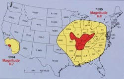
    What in the world is happening in the middle of the United States right now? Thousands of birds are falling dead from the skies, tens of thousands of fish are washing up on shore dead, earthquakes are popping up in weird and unexpected places and people are starting to get really freaked out about all of this. Well, one theory is that the New Madrid fault zone is coming to life. The New Madrid fault zone is six times bigger than the San Andreas fault zone in California and it covers portions of Illinois, Indiana, Missouri, Arkansas, Kentucky, Tennessee and Mississippi. The biggest earthquakes in the history of the United States were caused by the New Madrid fault. Now there are fears that the New Madrid fault zone could be coming to life again, and if a "killer earthquake" does strike it could change all of our lives forever.

    So exactly what events have happened recently that are causing people to take a close look at the New Madrid fault zone? Well, just consider the following examples of things that have been popping up in the news lately....

    *According to the U.S. Geological Survey, more than 500 measurable earthquakes have been recorded in central Arkansas just since September.

    *A magnitude-3.8 earthquake that shook north-central Indiana on December 30th is being called "unprecedented". It was strong enough to actually cause cracks along the ground and it was felt in portions of Ohio, Illinois, Wisconsin and Kentucky.

    *More than 3,000 red-wing blackbirds fell out of the sky dead in the Arkansas town of Beebe on New Year's Eve.

    *Large numbers of dead birds were also found in Kentucky right around Christmas.

    *Approximately 500 dead blackbirds and starlings were also recently discovered in Pointe Coupee Parish, Louisiana.

    *Approximately 100,000 fish washed up dead on the shores of the Arkansas River just last week.
    So could all of these things have some other very simple explanation?
    Possibly.

    But the fact that they all happened in or around the New Madrid fault zone is starting to raise some eyebrows.

    About 200 years ago, in 1811 and 1812, there were four earthquakes that were so powerful in the area of the New Madrid fault zone that they are still talked about today. All four of the quakes were estimated to have been magnitude-7.0 or greater. It is said that those earthquakes opened deep fissures in the ground, caused the Mississippi River to run backwards and that they were felt as far away as Boston.
    The last major earthquake to hit the region was a 5.4-magnitude quake that struck the town of Dale, Illinois in 1968. Things have been strangely quiet in the region since then until recently.

    If a true "killer earthquake" struck along the New Madrid fault zone today, cities such as St. Louis, Missouri and Memphis, Tennessee could potentially be completely destroyed.

    Unfortunately, this is not an exaggeration.

    The following video describes just how incredibly powerful the earthquakes along the New Madrid fault in 1811 and 1812 actually were....

    So could such a thing happen today?

    Well, that is exactly what many seismologists now fear. The following video news report from ABC News explains why so many scientists are so concerned about the New Madrid fault zone....

    One interesting theory is that the "oil volcano" unleashed by the BP oil spill in 2010 may have sparked renewed seismic activity in that part of the world.

    Jack M. Reed, a retired Texaco geologist-geophysicist, has been carefully studying the geology of the Gulf of Mexico for over 40 years. Reed is convinced that the Gulf of Mexico is currently tectonically active, and that the Gulf of Mexico is the source for most seismic activity along the New Madrid fault.

    According to Reed, there is substantial evidence that the New Madrid fault zone is directly connected to "deeply buried tectonics" in the Gulf of Mexico....
    "This entire zone through the United States is suffering some type of tectonic activity that I believe is tied to the deeply buried tectonics in the Gulf of Mexico."
    So did BP disturb those "deeply buried tectonics" by drilling such a deep well and unleashing all that oil that flowed into the Gulf of Mexico?
    Let's hope not.

    If a truly historic earthquake did strike along the New Madrid fault the amount of damage that could be done to surrounding states such as Illinois, Kentucky, Mississippi, Indiana, Alabama, Missouri, Arkansas and Tennessee could potentially be unimaginable.

    Jeremy Heidt of the Tennessee Emergency Management Agency says that life in the region would be instantly transformed in the event of a major earthquake along the New Madrid fault....
    "All communications would be out. All air travel would be out as the FAA air control would go down. All rail travel would fail. Ports would shut down; oil and natural gas pipelines could be off line."
    According to a recent study by the University of Illinois, a 7.7-magnitude earthquake along the New Madrid fault would leave 3,500 people dead, more than 80,000 injured and more than 7 million homeless.

    So what would happen if an 8.0 earthquake struck?

    Or an 8.5?

    Or a 9.0?

    Remember, an 8.7-magnitude earthquake would be ten times worse than a 7.7-magnitude earthquake.

    There are even some who believe that if a powerful enough earthquake hit the New Madrid fault someday it could potentially alter the surrounding geography enough that it could actually create a new major body of water in the middle of the United States.

    So, no, it is not just California that needs to worry about "the Big One".

    Right now seismic activity has been dramatically increasing all over the globe. Just think of the unprecedented number of volcanic eruptions that we have seen over the past year. Major earthquakes have been popping up all along the "Ring of Fire". Just over the past couple of days a magnitude-7.1 earthquake hit central Chile and a magnitude-7.0 earthquake struck northern Argentina.

    So to think that "it can't happen" in the United States is just being totally naive.

    Let us hope and pray that a devastating earthquake does not hit the New Madrid fault any time soon, because such an event could completely wipe out our economy. The U.S. economy is already teetering on the brink of disaster, and all it would take is one major blow to bring the entire house of cards crashing down.

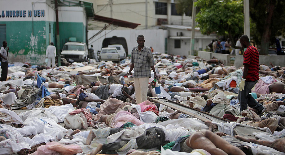
    Just remember what happened in Haiti. A magnitude-7.0 earthquake killed 230,000 people and caused such horrific devastation that it is still hard to even try to put it into words. The photo below shows how dead bodies were literally piled up in the streets during the aftermath of that disaster. Let us hope and pray that nothing like the scene pictured below happens in any U.S. city any time soon....


    To view links or images in signatures your post count must be 15 or greater. You currently have 0 posts.


    Nikita Khrushchev: "We will bury you"
    "Your grandchildren will live under communism."
    “You Americans are so gullible.
    No, you won’t accept
    To view links or images in signatures your post count must be 15 or greater. You currently have 0 posts.
    outright, but we’ll keep feeding you small doses of
    To view links or images in signatures your post count must be 15 or greater. You currently have 0 posts.
    until you’ll finally wake up and find you already have communism.

    To view links or images in signatures your post count must be 15 or greater. You currently have 0 posts.
    ."
    We’ll so weaken your
    To view links or images in signatures your post count must be 15 or greater. You currently have 0 posts.
    until you’ll
    To view links or images in signatures your post count must be 15 or greater. You currently have 0 posts.
    like overripe fruit into our hands."


  3. #143
    Expatriate American Patriot's Avatar
    Join Date
    Jul 2005
    Location
    A Banana Republic, Central America
    Posts
    48,612
    Thanks
    82
    Thanked 28 Times in 28 Posts

    Default Re: Earthquakes, Plate Tectonics and Volcanism

    Rock slides... they make a hell of a lot of noise.
    Libertatem Prius!


    To view links or images in signatures your post count must be 15 or greater. You currently have 0 posts.


  4. #144
    Postman vector7's Avatar
    Join Date
    Feb 2007
    Location
    Where it's quiet, peaceful and everyone owns guns
    Posts
    21,663
    Thanks
    30
    Thanked 73 Times in 68 Posts

    Default Re: Earthquakes, Plate Tectonics and Volcanism

    US FEMA Orders Survival Food for 7 Million People in New Madrid Zone

    RFI for Pre-Packaged Commercial Meals

    Solicitation Number: HSFEHQ-11-R-Meals
    Agency: Department of Homeland Security
    Office: Federal Emergency Management Agency
    Location: Logistics Section

    • Print
    • LinkCopy or Bookmark this Page


      Bookmark this page by right-clicking here and choosing "Bookmark This Link..."


    :
    HSFEHQ-11-R-Meals

    :
    Sources Sought

    :
    Added: Jan 20, 2011 11:54 am
    The Federal Emergency Management Agency (FEMA) procures and stores pre-packaged
    commercial meals to support readiness capability for immediate distribution to disaster
    survivors routinely. The purpose of this Request for Information is to identify sources of
    supply for meals in support of disaster relief efforts based on a catastrophic disaster event within
    the
    New Madrid Fault System for a survivor population of 7M to be utilized for the sustainment of
    life during a 10-day period of operations.


    FEMA is considering the following specifications (14M meals per day):


    - Serving Size - 12 ounce (entree not to exceed 480 calorie count);
    - Maximum calories - 1200 and/or 1165 per meal;
    - Protein parameters - 29g-37g kit;
    - Trans Fat - 0;
    - Saturated Fat - 13 grams (9 calories per gram);
    - Total Fat - 47 grams (less than 10% calories);
    - Maximum sodium - 800-930 mg;

    Requested Menus to include snacks (i.e. fruit mix, candy, chocolate/peanut butter squeezers, drink mix, condiments, and utensils). All meals/kits must have 36 months of remaining shelf life upon delivery. Packaging should be environmentally friendly.

    - Homestyle Chicken Noodles
    - Potatoes
    - Vegetarian Pasta
    - Green Pepper Steak w/Rice
    - BBQ sauce w/Beef and diced
    - Chicken w/Rice and Beans
    - Chicken Pasta

    The following questions are put forward to interested parties:

    1. Please specify the type of organization responding to the questions (i.e. small business, large business, industry association, etc.) If a small business, please specify all Small Business Administration socioeconomic programs under which your organization qualifies.

    2. Does your organization have a product available that meets all the specifications above?
    If the answer is "Yes:" What is the country of origin?

    If the answer is "No:" (a) Can your organization produce such a product? (b) What would be the product lead time? (c) What country are the manufacturing plants located in?

    3. Can your organization delivery the product to a specified location within a 24 hour period

    4. Please provide an implementation plan for critical delivery orders and delivery surge orders.


    5. What states do you already have contracts in place with to provide these types of products?

    6. Please detail the type of meals and quantities you can provide for each day following a disaster.

    7. Please provide alternatives to the meal specifications that your organization can provide.

    8. What type of delivery schedule would your organization recommend for the meals?

    9. Does your organization have the capabilities to deliver products directly to FEMA's CONUS Distributions Centers?

    10. Can your organization track deliveries from point of origin to point of delivery?

    11. What is your lead time for delivery once FEMA has placed an order?

    Interested parties may also provide brochures, web links, or other literature about their cots available for the specified users. Responses to this RFI are not considered offers and cannot be accepted by the Government to form a binding contract.

    Vendors are encouraged to ask the Government questions regarding this potential requirement. Questions must be submitted in writing to Julieann L. Phillips at julieann.phillips@dhs.gov not later than 2:00PM, 26 January 2011 to be answered. Responses to questions will be provided not later than 2:00PM, 03 February 2011.

    Request for Information closing date is 03 February 2011.


    :
    500 C Street SW
    Patriots Plaza -- 5th Floor
    Washington, District of Columbia 20472

    :
    Julieann L. Phillips,
    CONTRACTING OFFICER
    Julieann.phillips@dhs.gov
    Phone: 202-646-3234
    Fax: 202.646.1765

    RFI - Hydration Supplies for Disaster Relief

    Solicitation Number: HSFEHQ-11-R-Hydro
    Agency: Department of Homeland Security
    Office: Federal Emergency Management Agency
    Location: Logistics Section

    • Print
    • LinkCopy or Bookmark this Page


      Bookmark this page by right-clicking here and choosing "Bookmark This Link..."


    :
    HSFEHQ-11-R-Hydro

    :
    Sources Sought

    :
    Added: Jan 20, 2011 5:11 pm

    The Federal Emergency Management Agency (FEMA) procures and stores hydrated beverages to support readiness capability for immediate distribution to disaster survivors routinely. The purpose of this Request for Information is to identify sources of supply for hydration in support of disaster relief efforts based on a catastrophic disaster event within the New Madrid Fault System for a survivor population of 7M to be utilized for the sustainment of life during a 10-day period of operations. FEMA is considering the following specifications (210M liters per day):

    - Quantity of liters;

    - Product Standards - All water shall be produced, packaged, labeled, transported, stored and handled in accordance with Title 21, Code of Federal Regulations, Parts 101, 110, 129 and 165 and all other applicable Federal, state, and local laws and regulations. The beverages shall expire no sooner than one year and nine months from the date of delivery;

    - Primary Container - The water shall be packaged in single-service polyethylene terephthalate (PET) bottles with flat caps or similar packages suitable for water consumption. Bottles shall be 1 liter in size;

    - Packaging of Shipping Cases - Water shall be packed in the vendor's standard commercial casing, which shall be shipped on industry standard size pallets (48 inches by 40 inches). Pallets of hydrated beverages shall be fully covered on all sides (excluding the top and bottom) with a minimum of a double layer of stretch-wrap. The stretch wrap shall extend over the top of the packaged product by a minimum of six inches. Pallets shall be hardwood and designed for pick up from all four sides. Due to the many unknown circumstances which can arise during disaster response and recovery, it is possible that the beverages may be moved several times, may be double-stacked for storage, and may be stored in warehouses or stored outside with no protection in all types of weather. The potential vendor shall ensure that the hydrated beverages are packaged to withstand such handling as well as severe climatic conditions.
    The following questions are put forward to interested parties:

    1. Please specify the type of organization responding to the questions (i.e. small business, large business, industry association, etc.) If a small business, please specify all Small Business Administration socioeconomic programs under which your organization qualifies.

    2. Does your organization have a product available that meets all the specifications above?
    If the answer is "Yes:" What is the country of origin?
    If the answer is "No:" (a) Can your organization produce such a product? (b) What would be the product lead time? (c) What country are the manufacturing plants located in?

    3. Can your organization delivery the product to a specified location within a 24 hour period?

    4. Please provide an implementation plan for critical delivery orders and delivery surge orders.


    5. What states do you already have contracts in place with to provide these types of products?

    6. Please detail the type of hydrated beverages and quantities you can provide for each day following a disaster.

    7. Please provide alternatives to the hydrated beverage specifications that your organization can provide.

    8. What type of delivery schedule would your organization recommend for the hydrated beverages?

    9. Does your organization have the capabilities to deliver products directly to FEMA's CONUS Distributions Centers?

    10. Can your organization track deliveries from point of origin to point of delivery?

    11. What is your lead time for delivery once FEMA has placed an order?

    Interested parties may also provide brochures, web links, or other literature about their products available for the specified users. Responses to this RFI are not considered offers and cannot be accepted by the Government to form a binding contract.

    Vendors are encouraged to ask the Government questions regarding this potential requirement. Questions must be submitted in writing to Thomas Zaboski at thomas.zaboski@fema.gov not later than 2:00PM, 26 January 2011 to be answered. Responses to questions will be provided not later than 2:00PM, 03 February 2011. Request for Information closing date is 03 February 2011.


    :
    500 C Street SW
    Patriots Plaza -- 5th Floor
    Washington, District of Columbia 20472


    :
    Thomas Zaboski,
    Contract Specialist
    thomas.zaboski@fema.gov
    Phone: 202-646-7929

    RFI - Blankets for Disaster Relief

    Solicitation Number: HSFEHQ-11-R-Blankets
    Agency: Department of Homeland Security
    Office: Federal Emergency Management Agency
    Location: Logistics Section

    • Print
    • LinkCopy or Bookmark this Page


      Bookmark this page by right-clicking here and choosing "Bookmark This Link..."


    :
    HSFEHQ-11-R-Blankets

    :
    Sources Sought

    :
    Added: Jan 20, 2011 4:54 pm

    The Federal Emergency Management Agency (FEMA) procures and stores blankets to support readiness capability for immediate distribution to disaster survivors routinely. The purpose of this Request for Information is to identify sources of supply for blankets in support of disaster relief efforts based on a catastrophic disaster event within the New Madrid Fault System for a survivor population of 7M to be utilized for the sustainment of life during a 10-day period of operations. FEMA is considering the following specifications (14M blankets per day):

    - 100% cotton;
    - White;
    - 66" x 90"


    The following questions are put forward to interested parties:

    1. Please specify the type of organization responding to the questions (i.e. small business, large business, industry association, etc.) If a small business, please specify all Small Business Administration socioeconomic programs under which your organization qualifies.

    2. Does your organization have a product available that meets all the specifications above?
    If the answer is "Yes:" What is the country of origin?
    If the answer is "No:" (a) Can your organization produce such a product? (b) What would be the product lead time? (c) What country are the manufacturing plants located in?

    3. Can your organization delivery the product to a specified location within a 24 hour period?

    4. Please provide an implementation plan for critical delivery orders and delivery surge orders.


    5. What states do you already have contracts in place with to provide these types of products?

    6. Please detail the type of blankets and quantities you can provide for each day following a disaster.

    7. Please provide alternatives to the blanket specifications that your organization can provide.

    8. What type of delivery schedule would your organization recommend for the blankets?

    9. Does your organization have the capabilities to deliver products directly to FEMA's CONUS Distributions Centers?

    10. Can your organization track deliveries from point of origin to point of delivery?

    11. What is your lead time for delivery once FEMA has placed an order?

    Interested parties may also provide brochures, web links, or other literature about their products available for the specified users. Responses to this RFI are not considered offers and cannot be accepted by the Government to form a binding contract.

    Vendors are encouraged to ask the Government questions regarding this potential requirement. Questions must be submitted in writing to Robin Jones at robin.jones@fema.gov not later than 2:00PM, 26 January 2011 to be answered. Responses to questions will be provided not later than 2:00PM, 03 February 2011. Request for Information closing date is 03 February 2011.


    :
    500 C Street SW
    Patriots Plaza -- 5th Floor
    Washington, District of Columbia 20472

    :
    Robin Jones
    robin.jones@fema.gov
    Phone: 202-646-4677


    To view links or images in signatures your post count must be 15 or greater. You currently have 0 posts.


    Nikita Khrushchev: "We will bury you"
    "Your grandchildren will live under communism."
    “You Americans are so gullible.
    No, you won’t accept
    To view links or images in signatures your post count must be 15 or greater. You currently have 0 posts.
    outright, but we’ll keep feeding you small doses of
    To view links or images in signatures your post count must be 15 or greater. You currently have 0 posts.
    until you’ll finally wake up and find you already have communism.

    To view links or images in signatures your post count must be 15 or greater. You currently have 0 posts.
    ."
    We’ll so weaken your
    To view links or images in signatures your post count must be 15 or greater. You currently have 0 posts.
    until you’ll
    To view links or images in signatures your post count must be 15 or greater. You currently have 0 posts.
    like overripe fruit into our hands."


  5. #145
    Creepy Ass Cracka & Site Owner Ryan Ruck's Avatar
    Join Date
    Jul 2005
    Location
    Cincinnati, OH
    Posts
    25,061
    Thanks
    52
    Thanked 78 Times in 76 Posts

    Default Re: Earthquakes, Plate Tectonics and Volcanism

    Yellowstone Has Bulged as Magma Pocket Swells
    Some places saw the ground rise by ten inches, experts report.

    January 19, 2011

    Yellowstone National Park's supervolcano just took a deep "breath," causing miles of ground to rise dramatically, scientists report.

    The simmering volcano has produced major eruptions—each a thousand times more powerful than Mount St. Helens's 1980 eruption—three times in the past 2.1 million years. Yellowstone's caldera, which covers a 25- by 37-mile (40- by 60-kilometer) swath of Wyoming, is an ancient crater formed after the last big blast, some 640,000 years ago.

    (See "When Yellowstone Explodes" in National Geographic magazine.)

    Since then, about 30 smaller eruptions—including one as recent as 70,000 years ago—have filled the caldera with lava and ash, producing the relatively flat landscape we see today.

    But beginning in 2004, scientists saw the ground above the caldera rise upward at rates as high as 2.8 inches (7 centimeters) a year. (Related: "Yellowstone Is Rising on Swollen 'Supervolcano.'")

    The rate slowed between 2007 and 2010 to a centimeter a year or less. Still, since the start of the swelling, ground levels over the volcano have been raised by as much as 10 inches (25 centimeters) in places.

    "It's an extraordinary uplift, because it covers such a large area and the rates are so high," said the University of Utah's Bob Smith, a longtime expert in Yellowstone's volcanism.

    Scientists think a swelling magma reservoir four to six miles (seven to ten kilometers) below the surface is driving the uplift. Fortunately, the surge doesn't seem to herald an imminent catastrophe, Smith said. (Related: "Under Yellowstone, Magma Pocket 20 Percent Larger Than Thought.")

    "At the beginning we were concerned it could be leading up to an eruption," said Smith, who co-authored a paper on the surge published in the December 3, 2010, edition of Geophysical Research Letters.

    "But once we saw [the magma] was at a depth of ten kilometers, we weren't so concerned. If it had been at depths of two or three kilometers [one or two miles], we'd have been a lot more concerned."

    Studies of the surge, he added, may offer valuable clues about what's going on in the volcano's subterranean plumbing, which may eventually help scientists predict when Yellowstone's next volcanic "burp" will break out.

    Yellowstone Takes Regular Breaths

    Smith and colleagues at the U.S. Geological Survey (USGS) Yellowstone Volcano Observatory have been mapping the caldera's rise and fall using tools such as global positioning systems (GPS) and interferometric synthetic aperture radar (InSAR), which gives ground-deformation measurements.

    Ground deformation can suggest that magma is moving toward the surface before an eruption: The flanks of Mount St. Helens, for example, swelled dramatically in the months before its 1980 explosion. (See pictures of Mount St. Helens before and after the blast.)

    But there are also many examples, including the Yellowstone supervolcano, where it appears the ground has risen and fallen for thousands of years without an eruption.

    According to current theory, Yellowstone's magma reservoir is fed by a plume of hot rock surging upward from Earth's mantle. (Related: "New Magma Layer Found Deep in Earth's Mantle?")

    When the amount of magma flowing into the chamber increases, the reservoir swells like a lung and the surface above expands upward. Models suggest that during the recent uplift, the reservoir was filling with 0.02 cubic miles (0.1 cubic kilometer) of magma a year.

    When the rate of increase slows, the theory goes, the magma likely moves off horizontally to solidify and cool, allowing the surface to settle back down.

    Based on geologic evidence, Yellowstone has probably seen a continuous cycle of inflation and deflation over the past 15,000 years, and the cycle will likely continue, Smith said.

    Surveys show, for example, that the caldera rose some 7 inches (18 centimeters) between 1976 and 1984 before dropping back about 5.5 inches (14 centimeters) over the next decade.

    "These calderas tend to go up and down, up and down," he said. "But every once in a while they burp, creating hydrothermal explosions, earthquakes, or—ultimately—they can produce volcanic eruptions."

    Yellowstone Surge Also Linked to Geysers, Quakes?


    Predicting when an eruption might occur is extremely difficult, in part because the fine details of what's going on under Yellowstone are still undetermined. What's more, continuous records of Yellowstone's activity have been made only since the 1970s—a tiny slice of geologic time—making it hard to draw conclusions.

    "Clearly some deep source of magma feeds Yellowstone, and since Yellowstone has erupted in the recent geological past, we know that there is magma at shallower depths too," said Dan Dzurisin, a Yellowstone expert with the USGS Cascades Volcano Observatory in Washington State.

    "There has to be magma in the crust, or we wouldn't have all the hydrothermal activity that we have," Dzurisin added. "There is so much heat coming out of Yellowstone right now that if it wasn't being reheated by magma, the whole system would have gone stone cold since the time of the last eruption 70,000 years ago."

    The large hydrothermal system just below Yellowstone's surface, which produces many of the park's top tourist attractions, may also play a role in ground swelling, Dzurisin said, though no one is sure to what extent.

    "Could it be that some uplift is caused not by new magma coming in but by the hydrothermal system sealing itself up and pressurizing?" he asked. "And then it subsides when it springs a leak and depressurizes? These details are difficult."

    And it's not a matter of simply watching the ground rise and fall. Different areas may move in different directions and be interconnected in unknown ways, reflecting the as yet unmapped network of volcanic and hydrothermal plumbing.

    The roughly 3,000 earthquakes in Yellowstone each year may offer even more clues about the relationship between ground uplift and the magma chamber.

    For example, between December 26, 2008, and January 8, 2009, some 900 earthquakes occurred in the area around Yellowstone Lake.

    This earthquake "swarm" may have helped to release pressure on the magma reservoir by allowing fluids to escape, and this may have slowed the rate of uplift, the University of Utah's Smith said. (Related: "Mysterious 'Swarm' of Quakes Strikes Oregon Waters.")

    "Big quakes [can have] a relationship to uplift and deformations caused by the intrusion of magma," he said. "How those intrusions stress the adjacent faults, or how the faults might transmit stress to the magma system, is a really important new area of study."

    Overall, USGS's Dzurisin added, "the story of Yellowstone deformation has gotten more complex as we've had better and better technologies to study it."

  6. #146
    Expatriate American Patriot's Avatar
    Join Date
    Jul 2005
    Location
    A Banana Republic, Central America
    Posts
    48,612
    Thanks
    82
    Thanked 28 Times in 28 Posts

    Default Re: Earthquakes, Plate Tectonics and Volcanism

    Well, it ain't gonna blow huh?

    lol

    They really, honestly don't have any knowledge one way or the other that 2 km or 10 km is enough to cause an eruption, now do they?
    Libertatem Prius!


    To view links or images in signatures your post count must be 15 or greater. You currently have 0 posts.


  7. #147
    Expatriate American Patriot's Avatar
    Join Date
    Jul 2005
    Location
    A Banana Republic, Central America
    Posts
    48,612
    Thanks
    82
    Thanked 28 Times in 28 Posts

    Default Re: Earthquakes, Plate Tectonics and Volcanism

    Japanese volcano Shinmoedake shatters windows 8km away


    1 February 2011 Last updated at 08:58 ET

    A volcano on Kyushu in Japan has erupted again with its biggest explosion yet, shattering windows 5 miles (8 kilometres) away.


    Shinmoedake first showed signs of new life last Wednesday, since when fine ash clouds have been raining down on the area.


    Volcanic debris, including hot ash and rocks, was sent more than 2,000m (6,500ft) into the air.


    Officials have widened the danger zone around Mount Kirishima, the location of the volcano and the setting for the 1967 James Bond movie You Only Live Twice.
    Libertatem Prius!


    To view links or images in signatures your post count must be 15 or greater. You currently have 0 posts.


  8. #148
    Expatriate American Patriot's Avatar
    Join Date
    Jul 2005
    Location
    A Banana Republic, Central America
    Posts
    48,612
    Thanks
    82
    Thanked 28 Times in 28 Posts

    Default Re: Earthquakes, Plate Tectonics and Volcanism

    1 February 2011 Last updated at 03:47 ET Fresh blast rocks south Japan volcano


    Shinmoedake erupts again, breaking windows miles away

    Continue reading the main story Related Stories


    A violent blast from Shinmoedake, a volcano erupting in Kyushu, Japan, has broken windows 8km (five miles) away.


    Building were showered with glass and the volcano threw out huge clouds of ash and gas. Hundreds of people have already fled their homes.


    It was the most dramatic bang so far from the peak on Mount Kirishima, the location of the 1967 James Bond movie You Only Live Twice.


    Volcanologists have warned of more large blasts and possible lava flows.


    Since the volcano showed signs of life last Wednesday, the government has widened the exclusion zone to a 4km (2.4 mile) radius from the peak.


    It is the first major activity at Shinmoedake in 52 years.


    The latest bang could be heard more than 7km (4.3 miles) away, Japan's NHK television reported.


    "I heard the bang then felt the boom, which was like wind pressure," one unidentified resident told reporters.


    Volcanic debris, including hot ash and rocks, was sent more than 2,000m (6,500ft) into the air; fine ash clouds have continued to rain down on the area.


    No serious injuries have been reported, although an elderly woman was cut by flying glass. Hundreds of windows were smashed by the blast, officials said.


    Domestic flights in and out of Miyazaki - about 950km (590 miles) south-west of Tokyo - were grounded last week.


    Train services and schools have also been affected.


    Volcanologists said that a dome of lava was growing larger inside the volcano's crater but it remained uncertain whether it would spill over the mountain's rim.
    Libertatem Prius!


    To view links or images in signatures your post count must be 15 or greater. You currently have 0 posts.


  9. #149
    Creepy Ass Cracka & Site Owner Ryan Ruck's Avatar
    Join Date
    Jul 2005
    Location
    Cincinnati, OH
    Posts
    25,061
    Thanks
    52
    Thanked 78 Times in 76 Posts

    Default Re: Earthquakes, Plate Tectonics and Volcanism

    Swarm of Unexplained Earthquake Strikes Arkansas
    February 17, 2011

    Jim Sutterfield was briefly puzzled by a thumping sound that seemed to slam the back of his office chair. But when the small-town Arkansas fire chief turned and saw no one was around, he quickly realized it was just an earthquake — again.

    "That was only my second time to feel one, but others here have felt them for three or four months now," Greenbrier chief Jim Sutterfield said after feeling the latest tremor on Wednesday. "Now when it happens, people say, 'Well, there's another one.'"

    Several small earthquakes ranging in magnitude from 1.8 to 3.8 have rattled the north-central Arkansas cities of Greenbrier and Guy this week, and the cause is unknown.

    The U.S. Geological Survey has reported more than 30 earthquakes in the area since Sunday, including a magnitude 3.8 quake Thursday morning and at least 16 others occurring Wednesday, two of which were magnitude 3.2 and 3.5. More than 700 quakes have occurred in the region over the past six months.

    Scott Ausbrooks, geohazards supervisor for the Arkansas Geological Survey, said the quakes are part of what is now called the Guy earthquake swarm — a series of mild earthquakes that have been occurring periodically since 2009. A similar swarm occurred in the early 1980s when a series of quakes hit Enola, Ark.

    Ausbrooks said geologists are still trying to discover the exact cause of the recent seismic activity but have identified two possibilities.

    "It could just be a naturally occurring swarm like the Enola swarm, or it could be related to ongoing natural gas exploration in the area," he said.

    A major source of natural gas in Arkansas is the Fayetteville Shale, an organically-rich rock formation in north-central Arkansas. Drillers free up the gas by using hydraulic fracturing or "fracking" — injecting pressurized water to create fractures deep in the ground.

    Ausbrooks said geologists don't believe the production wells are the problem, but rather the injection wells that are used to dispose of "frack" water when it can no longer be re-used. The wastewater is pressurized and injected into the ground.

    "We see no correlation between natural gas production wells and earthquakes, but we haven't ruled out injection wells," he said, adding that if production wells were the cause, the earthquakes would be scattered all over the region underlain by the Fayetteville Shale formation and not in just one area.

    Ausbrooks said the earthquakes are occurring in the vicinity of several injection wells.

    Guy Police Chief Dave Martini said the locals continue to blame the gas companies for the quakes.

    "We have a disposal well here just outside of the city," Martini said. "People are suspecting that to be causing it, even though there isn't any proof of that."

    Martini said the earthquakes started increasing in frequency over the past week and that the disposal well has seen an increase in use recently.

    Lawrence Bengal, director of the Arkansas Oil and Gas Commission, said a six-month moratorium was established in January on new injection wells in the area. He said four companies are operating already-drilled injection wells: SEECO Inc., Chesapeake Operating Inc., Clarita Operating LLC and Deep-Six Water Disposal Services LLC.

    The moratorium, which is expected to end in July, is intended to allow time to study the relationship — if any — between the injection wells and earthquakes in the area.

    The largest quake of the Guy Earthquake Swarm was a magnitude 4.0, which occurred in October, Ausbrooks said. The region could possibly see quakes reaching as high as 5.0, but he said anything above 6.0 is unlikely.

    The magnitude scale for earthquakes is logarithmic, meaning a magnitude 3 earthquake would produce waves with amplitudes 10 times greater than a magnitude 2 and 100 times greater than a magnitude 1. Geologists say quakes of magnitude 2.5 to 3.0 are generally the smallest felt by humans.

    "These periods of high activity are not uncommon. I don't think it's anything to be overly concerned about," Ausbrooks said. "We always encourage people to keep tuned in to what's going on and to always have an all-hazards disaster preparedness kit."

  10. #150
    Creepy Ass Cracka & Site Owner Ryan Ruck's Avatar
    Join Date
    Jul 2005
    Location
    Cincinnati, OH
    Posts
    25,061
    Thanks
    52
    Thanked 78 Times in 76 Posts

    Default Re: Earthquakes, Plate Tectonics and Volcanism

    3.5 Magnitude Earthquake Off the Coast of Alabama
    Epicenter is less than 10 miles off the coast of Baldwin County in the Gulf of Mexico

    February 18, 2011

    The United States Geological Survey confirms a 3.5 magnitude earthquake in the Gulf of Mexico.

    It happened at 5:15 p.m. at coordinates 30.180°N, 87.848°W, about 10 miles off the coast, near the tip of the Fort Morgan Peninsula at the mouth of Mobile Bay.

    News 5 first heard from a man on Dauphin Island who says his home, which is on pilings, swayed back and forth for at least five seconds. We also received a call from a woman in Orange Beach who also felt the shaking in her second floor condo.

    The USGS has received 81 reports of light shaking. Most of those are from Orange Beach (34) and Dauphin Island (15). People have reported feeling the quake as far north as Birmingham, as far east as Port Richey, Florida and as far west as Saucier, Mississsippi.

    News 5 talked to an earthquake expert from Mobile. Gene Longenecker, who graduated from UMS-Wright, is the Southeast Earthquake Program Manager for FEMA. Longenecker says with quakes here on the coast, the most you expect is some light shaking.

    The last earthquake in our area was March, 22, 2005. The epicenter of the 3.3 magnitude quake was in Coffeville.

  11. #151
    Creepy Ass Cracka & Site Owner Ryan Ruck's Avatar
    Join Date
    Jul 2005
    Location
    Cincinnati, OH
    Posts
    25,061
    Thanks
    52
    Thanked 78 Times in 76 Posts

    Default Re: Earthquakes, Plate Tectonics and Volcanism

    Arkansas' 4.7 Quake Reported Felt In Southern Iowa
    February 28, 2011

    An earthquake that shook Arkansas Sunday night was reported to have been felt in southern Iowa's Appanoose County.

    An unidentified person in Plano, a small town in western Appanoose County, reported to the U.S. Geological Survey that they felt the tremor at 11 p.m. Plano is southwest of Lake Rathbun and not far from the Missouri border. People in at least four other states also reported feeling the earthquake, one of four earthquakes recorded late Sunday and early Monday near Greenbrier in central Arkansas.

    Ray Anderson, a geologist with the Iowa Geological and Water Survey in Iowa City, said it's possible a 4.7 magnitude earthquake in Arkansas could be felt in Iowa. "It would kind of feel like a truck driving by," he said.

    Appanoose County Sheriff Gary Anderson said his office received no reports Sunday night or Monday morning of county residents feeling earthquake tremors.

  12. #152
    Expatriate American Patriot's Avatar
    Join Date
    Jul 2005
    Location
    A Banana Republic, Central America
    Posts
    48,612
    Thanks
    82
    Thanked 28 Times in 28 Posts

    Default Re: Earthquakes, Plate Tectonics and Volcanism

    Arkansas has been having quakes for a month or so already. I was talking about this yesterday. Now today, Alabama...

    Global Warming? Yellowstone related???

    Big fault running through there perhaps?
    Libertatem Prius!


    To view links or images in signatures your post count must be 15 or greater. You currently have 0 posts.


  13. #153
    Creepy Ass Cracka & Site Owner Ryan Ruck's Avatar
    Join Date
    Jul 2005
    Location
    Cincinnati, OH
    Posts
    25,061
    Thanks
    52
    Thanked 78 Times in 76 Posts

    Default Re: Earthquakes, Plate Tectonics and Volcanism

    Strong Quake Hits Northeast Japan, Tsunami Warning Issued
    March 9, 2011

    A strong earthquake with a preliminary magnitude of 7.2 struck off the coast of northeast Japan Wednesday, the Japanese Meteorological Agency (JMA) said, but there were no reports of damage or injuries.

    A tsunami advisory of up to 50 cm (20 inches) was issued for northeastern Japan after the quake, which occurred at around 11:45 a.m. (0245 GMT), the JMA said, and a 60 cm (24 inch) wave reached Ofunato port, about 450 km (280 miles) from Tokyo, Kyodo news agency said.

    "First I felt a jolt that pushed from underneath, then a big sideways tremor that lasted for about 20 seconds," Yoshiyuki Sato, an official at Kurihara City in Miyagi prefecture, about 300 km (186 miles) northeast of Tokyo, told Reuters.

    "The tremor was relatively big but things did not fall off the shelves in the city government building," he said.

    The focus of the tremor was 10 km (6 miles) below the seabed off the coast of Aomori prefecture, public broadcaster NHK said.

    The regional utility, Tohoku Electric Power, said its Onagawa nuclear plant was operating normally after the quake. Tokyo Electric Power Co Inc also said there was no impact on its power plants in the region.

    Bullet trains resumed running in northeastern Japan after stopping briefly, Kyodo reported.

    Japan's northeast Pacific coast, called Sanriku, has suffered from quakes and tsunamis in the past. In 1933, a magnitude 8.1 quake in the area killed over 3,000 people, and last year fishing facilities were damaged after by tsunami caused by a strong tremor in Chile.

    Earthquakes are common in Japan, one of the world's most seismically active areas. The country accounts for about 20 percent of the world's earthquakes of magnitude 6 or greater.

  14. #154
    Expatriate American Patriot's Avatar
    Join Date
    Jul 2005
    Location
    A Banana Republic, Central America
    Posts
    48,612
    Thanks
    82
    Thanked 28 Times in 28 Posts

    Default Re: Earthquakes, Plate Tectonics and Volcanism

    OMG a 20" tsunami! They're DOOMED!
    Libertatem Prius!


    To view links or images in signatures your post count must be 15 or greater. You currently have 0 posts.


  15. #155
    Expatriate American Patriot's Avatar
    Join Date
    Jul 2005
    Location
    A Banana Republic, Central America
    Posts
    48,612
    Thanks
    82
    Thanked 28 Times in 28 Posts

    Default Re: Earthquakes, Plate Tectonics and Volcanism

    At four meters, he don't come back. The monster eats him.

    /chuckles

    There was something I posted a few days ago about this in England. A Loch Ness type of critter. I think I posted it under the skeptics area.
    Libertatem Prius!


    To view links or images in signatures your post count must be 15 or greater. You currently have 0 posts.


  16. #156
    Expatriate American Patriot's Avatar
    Join Date
    Jul 2005
    Location
    A Banana Republic, Central America
    Posts
    48,612
    Thanks
    82
    Thanked 28 Times in 28 Posts

    Default Re: Earthquakes, Plate Tectonics and Volcanism

    You might be hearing that newly wed couple next door too......
    Libertatem Prius!


    To view links or images in signatures your post count must be 15 or greater. You currently have 0 posts.


  17. #157
    Expatriate American Patriot's Avatar
    Join Date
    Jul 2005
    Location
    A Banana Republic, Central America
    Posts
    48,612
    Thanks
    82
    Thanked 28 Times in 28 Posts

    Default Re: Earthquakes, Plate Tectonics and Volcanism

    You know, Peterle.... there are monsters out there. Monsters of the Deep.

    And I suspect you will eventually see one.

    http://en.wikipedia.org/wiki/Giant_squid

    In this photo released by Tsunemi Kubodera, a researcher with Japan's National Science Museum, a giant squid attacking a bait squid is pulled up by his research team off the Ogasawara Islands, south of Tokyo, on December 4, 2006. The research team, led by Kubodera, succeeded in filming the giant squid live, possibly for the first time, at the surface as they captured it off the remote island of Chichijima, which is about 600 miles (960 kilometers) southeast of Tokyo. About 24 feet (seven meters) long, the squid died in the process of being caught. The photo was made out of the video they filmed.


    Photo of a large Grizzly Bear also known as a silvertip bear in Denali National Park.

    Of course, none of these cause Earthquakes. LOL
    Libertatem Prius!


    To view links or images in signatures your post count must be 15 or greater. You currently have 0 posts.


  18. #158
    Creepy Ass Cracka & Site Owner Ryan Ruck's Avatar
    Join Date
    Jul 2005
    Location
    Cincinnati, OH
    Posts
    25,061
    Thanks
    52
    Thanked 78 Times in 76 Posts

    Default Re: Earthquakes, Plate Tectonics and Volcanism

    New thread for the recent breaking news on the Japan earthquake, HI tsunami warning, and West Coast tsunami watch here.

  19. #159
    Expatriate American Patriot's Avatar
    Join Date
    Jul 2005
    Location
    A Banana Republic, Central America
    Posts
    48,612
    Thanks
    82
    Thanked 28 Times in 28 Posts

    Default Re: Earthquakes, Plate Tectonics and Volcanism

    On earthquakes, eruptions and the moon

    Erik Klemetti on March 11, 2011, 11:18 AM


    Note: I wrote this before the M8.9 earthquake in Japan last night.


    Remember, the earthquake occurred on March 11-12, not March 15 or March 19, the dates of these so-called astronomical events. You can't call for increased activity on a certain date and then lay claim to every event for weeks before and after - that is fitting the data to your model. Most likely, this new earthquake was triggered - or at least foreshadowed - by the M7.2 earthquake earlier this week. These earthquakes are all normal operations in subduction zones: when that stored energy is released, large earthquakes can occur, with or without the "help" of the moon.

    ------
    I've had a number of questions lately about a couple of events coming up this month astronomically and how they might effect geologic events - namely earthquakes and volcanoes - on Earth. I can tell you right now, without much doubt, that the answer, even before I tell you the question, is very, very little.


    Now, the questions: (1) How will the close passage of Comet Elenin and Earth cause geologic catastrophes on March 15 and (2) How will the so-called "Supermoon", a full moon when the moon is closest to Earth in its orbit, cause geologic catastrophes?


    I know there has long been a desire to show about the gravitational resonance of planets/comets/asteroids/the sun might play a role in Earth's geologic activity - and with some logic. We see the interaction of the Earth's surface with the Moon's gravity (and to some extent the Sun's) with the tides in the oceans. Water has low viscosity so the tidal tugging of the moon as it rotates around the Earth sloshes the oceans back and forth to create our tides. One could imagine that the Earth's crust/mantle/core might feel some of that gravitational interaction as well - and they do. John Vidale, a seismologist at the University of Washington, mentions that during full and new moons - when the moon is oriented between or opposite the Earth and the sun - there is potentially as much as a 1% increase in earthquake activity worldwide (and a slightly higher effect on volcanic activity). Let me repeat that: 1%. In any natural, geologic process that is mostly distributed randomly through time like earthquakes, 1% or there about is well within the "noise" of processes, so would these alignments produce much of a discernable increase? Probably not and this is with the two bodies that play the largest role in tidal forcing on Earth. There are other studies that suggest that this tidal tugging and pulling can cause small shifts in fault systems like the San Andreas, but one might argue that the moon is, in fact, "passively" releasing seismic energy on the fault, thus preventing or delaying large earthquakes! Trying to say that any other astronomical body might, even in some specific alignment, might cause more than a 1% increase in the chance of activity is remote at best.
    Some of the so-called evidence for this moon-earthquake relationship is specious at best. From a National Geographic article on the "lunar connection" back in 2005: "At least two major quakes may support [James A.] Berkland's theory. The December 26, 2004, magnitude 9.1 in Sumatra, Indonesia, occurred on the day of a full moon. Likewise, the March 27, 1964, magnitude 9.2 earthquake in Alaska occurred on the day of maximum high tide. According to Berkland, such correlations are more than coincidences. They demonstrate a true connection between the moon and earthquake activity." First off, two earthquakes coinciding with full moons is hardly scientific, statistically-sound evidence. How many "large" earthquakes (and who defines that anyway?) occur when it isn't a full moon? And how many full moons have we had when there wasn't a "large" earthquake? I've said this before, but it is an easy trap - correlation does not mean causation. Full moons happen 12 (maybe 13) times a year, so if you randomly sprinkle earthquakes through time, many large ones are bound to coincide with the full moon. USGS seismologist Dr. John Bellini followed up on Berkland's theories: "Bellini questioned the scientific validity of Berkland's predictions. He said they appear to be "self-selected statistical analysis of historical seismicity rates and are so vague in time and location that they are certain to be correct."
    Now, as for the Moon's relative position to Earth and its effect, the Moon when it is at least closest is 356,401 km from the Earth's surface and at its furthest, it is 406,700 km (with an average distance of 384,401 km. That is a difference of ~50,300 km ~ in other words, when the Moon is closest to Earth, it is ~12% closer than it is at its furthest. Newtonian physics tells us that the attraction between the Earth and the Moon is dictated by F = GM1M2/R^2, where M1 and M2 are the masses of the Earth and Moon, G is the gravitational constant and R is the distance between the two bodies. Even a ~12% change in that value means that the force of gravity, in Newtons, only changes by ~30% at maximum (and only ~11% difference from average), a change that happens gradually as the Moon moves around its orbit. We see this fairly small change with different sized tides, but even those changes are not "disastrous". When you consider the energy needed to move tectonic plates (or even the oceans), this change in gravitational energy from the Earth-Moon system is small. Remember, that the Moon is at its closest once a month, so just because it happens during a full moon doesn't mean that the gravitational pull from the Moon is any stronger than it would be at any other perigee. Remember, the Moon reaches perigee every month and you don't see massive earthquakes and eruptions every time this happens.
    Some planetary bodies do see a profound effect of tidal forces. The moons of Jupiter areconstantly being tugged by the high gravity of Jupiter as the whiz around the gas giant. You can see that constant, frictional energy being imparted on the rocks of the moons in the relative geologic activity on the Galilean satellites - closest to Jupiter lies Io (at ~420,000 km), the most volcanically active body in the solar system. It gets tugged by a force 300% more than the Moon pulls on Earth. Next comes Europa (at ~664,000 km), where there are suggestions that liquid or slushy subsurface water exists due to tidal heating. Ganymede and Callisto, even further from Jupiter, show much fewer signs of liquid water or extensive tidal heating. The gravity of Jupiter is the direct cause for the geologic activity on these small planetary bodies.

    The lava flow from the Kamoamoa Fissure snaking around an old crater on Kilauea, as seen on March 10, 2011. This eruption did not start during a full/new moon. Image courtesy of HVO/USGS.
    As I mentioned before, this sort of "correlation" of astronomical alignments and geologic disasters have been predicted before - with results that were coincidental at best. Back in 2006, there was rampant speculation about how a full moon was going to trigger an eruption of Mayon in the Philippines … and it didn't. In a USGS article about volcanoes and the moon, they make the point that it does appear that activity at some volcanoes, like Kilauea, are effected by lunar cycles - however, this does not mean that an eruption at any specific volcano worldwide can be predicted using lunar cycles. There are just too many other variables, so unless the volcano is already erupting, such as Kilauea (see above from an eruption that didn't start on a new/full moon), don't expect the Moon to bring volcanoes to life. Even if the volcano is predisposed to be close to eruption (and even defining that is difficult), there is no data to support this (to borrow a quote from a paper that Chris Rowan's uses in a post on the subject): "We found no conclusive evidence for a general correlation between volcanic activity and lunar tidal phase. This result is consistent with recent work which indicates that diurnal and fortnightly tidal stresses may be too short-lived and strain rates too high to effect a significant viscous response in partially molten regions of the Earth’s subsurface." (Mason et al., 2004). During this Mayon hype in 2006, Phil Piatt also took on these predictions and points out the biggest flaw with many of these "correlations": "It’s small number statistics, like flipping a coin three times and having it come up heads each time. It’s rare, but it does happen on average one out of every eight times. You need bigger samples to get good statistics." Science requires data that can show a valid correlation, not picking what fits best to your ideas.
    If anything, we should be concentrating on terrestrial forcing for "predicting" earthquakes. It could be that changes in the stregth of the Earth's magnetic field, due to the thickness and composition of the Earth, but might help find earthquake-prone locations. A study in Science by Song and Simons from 2003 examined the gravity anomaly (how much the gravitational field from the Earth varies from the norm) along a subduction and then compared it to a long historical record of seismicity. It found that "within a given subduction zone, areas with negative gravity anomalies correlated with increased large earthquake activity. Areas with relatively high gravity anomalies experienced fewer large earthquakes." However, how we can use the changes in gravity anomaly to predict earthquakes is still very unclear.
    So, what can we take away from all this?

    • The Moon plays a very small role in increasing seismicity and volcanic activity on Earth - potentially increasing activity ~1% during full/new moons.
    • The change in the gravitational pull from the Moon during apogee and perigee is small.
    • Beyond this, there is no statistically-sound evidence that geologic disasters can be predicted based on lunar alignments or distance (or any other astronomical phenomena).
    • The keys to understanding how to predict earthquakes or eruptions (if at all possible) lie within the Earth, not deep in space.

    Top left: The moon. It's friendly, really.
    Libertatem Prius!


    To view links or images in signatures your post count must be 15 or greater. You currently have 0 posts.


  20. #160
    Expatriate American Patriot's Avatar
    Join Date
    Jul 2005
    Location
    A Banana Republic, Central America
    Posts
    48,612
    Thanks
    82
    Thanked 28 Times in 28 Posts

    Default Re: Earthquakes, Plate Tectonics and Volcanism

    7.0 Mw - MYANMAR

    Preliminary Earthquake Report
    Magnitude
    7.0 Mw
    Date-Time
    · 24 Mar 2011 13:55:12 UTC
    · 24 Mar 2011 20:25:12 near epicenter
    · 24 Mar 2011 06:55:12 standard time in your timezone
    Location
    20.705N 99.948E
    Depth
    10 km
    Distances
    · 90 km (56 miles) N (8 degrees) of Chiang Rai, Thailand
    · 168 km (104 miles) SSW (213 degrees) of Yunjinghong, Yunnan, China
    · 233 km (145 miles) NNW (337 degrees) of Muang Nan, Thailand
    · 235 km (146 miles) NNE (25 degrees) of Chiang Mai, Thailand
    · 413 km (257 miles) NW (317 degrees) of VIENTIANE, Laos
    Location Uncertainty
    Horizontal: 15.4 km; Vertical 5.8 km
    Parameters
    Nph = 109; Dmin = 234.9 km; Rmss = 0.88 seconds; Gp = 36°
    M-type = Mw; Version = C

    Event ID
    US c0002aes
    For updates, maps, and technical information, see:
    Event Page

    or
    USGS Earthquake Hazards Program

    National Earthquake Information Center
    U.S. Geological Survey
    http://neic.usgs.gov
    /
    Libertatem Prius!


    To view links or images in signatures your post count must be 15 or greater. You currently have 0 posts.


Thread Information

Users Browsing this Thread

There are currently 1 users browsing this thread. (0 members and 1 guests)

Bookmarks

Posting Permissions

  • You may not post new threads
  • You may not post replies
  • You may not post attachments
  • You may not edit your posts
  •