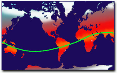
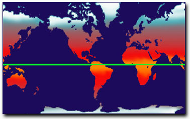
The evidence proving that the poles where in different positions during the Pleistocene era is quite impressive, and this explains why Hapgood's theory was approved by scientists such as Einstein and K.F. Mather. But his theory meets with so many difficulties that it becomes highly controversial. Above all, it seems to conflict with widely accepted theories, such as the drift of the continents. Hapgood, while credited with correctly plotting the positions of past polar coordinates, was forced to adhere to a much slower transition of the poles, accepting the paradigm of continental drift and plate tectonics to maintain the support of the scientific community. Ironically, one of the most recent objections to Hapgood's theory is the rapidity of climate changes that occurred in the Pleistocene period. According to Hapgood's revised theory, it took the North Pole at least two thousand years to move from its previous position to the present. The evidence we now have, however, definitely points to much faster climatic changes.
It was Hapgood himself who first underscored the enormous amount of evidence proving the high speed at which the shift of the poles appears to have happened; speed which the mechanism of continental drift is unable to explain.
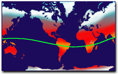
The only way to completely and coherently explain what took place at the end of Pleistocene era appears to be that of admitting the possibility of a shift of the poles of the same magnitude Hapgood hypothesizes, but in a much shorter time: not more than a few days! This possibility is openly refused, only because no convincing explanation has been forwarded so far. It would, however, support the abrupt disaster that befell Atlantis -- if it is under Antarctica's polar ice cap. With no hard data to explain this extremely abrupt disturbance in geography, Hapgood continued aligned with the theory of a gradual shift. In the forward to a book on the subject, Hapgood wrote: "Polar wandering is based on the idea that the outer shell of the earth shifts about from time to time, moving some continents toward and other continents away from the poles. Continental drift is based on the idea that the continents move individually... A few writers have suggested that perhaps continental drift causes polar wandering. This book advances the notion that polar wandering is primary and causes the displacement of continents.... This book will present evidence that the last shift of the earth's crust (the lithosphere) took place in recent time, at the close of the last ice age, and that it was the cause of the improvement in climate." --(The Path of the Pole by Chilton.) New Evidence -- Enter STONEHENGE!
Thomas O. Mills has written extensively on the Hopi culture -- the oldest Native American tribe. The Hopi are extremely private people who do not usually share their cultural secrets with outsiders. Mills has been fortunate to live with the Hopi and has come to appreciate their depth of knowledge of nature. He is particularly fascinated by their understanding of celestial alignments.
In his book, Stonehenge: If This Were East, Mills shows what he calls the Hopi Truth Wheel. This is a compass like circle that, when aligned to the North Pole, reveals the direction of the Sun and certain significant stars for the Equinox and Summer and Winter Solstice. Mills examined the possibility that Stonehenge might have utilized this same Truth Wheel in its construction. His results were quite remarkable.
The current alignment of Stonehenge makes no sense as to important alignments thought to be useful to the ancients who made it. This is why there has been great controversy and argument over the original purpose of the placement of the stones. But when Mills placed his "wheel of truth" over Stonehenge he immediately noticed that the stones were in perfect alignment. There was only one problem -- they didn't align with the North Pole.
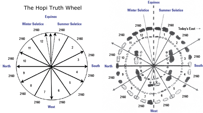
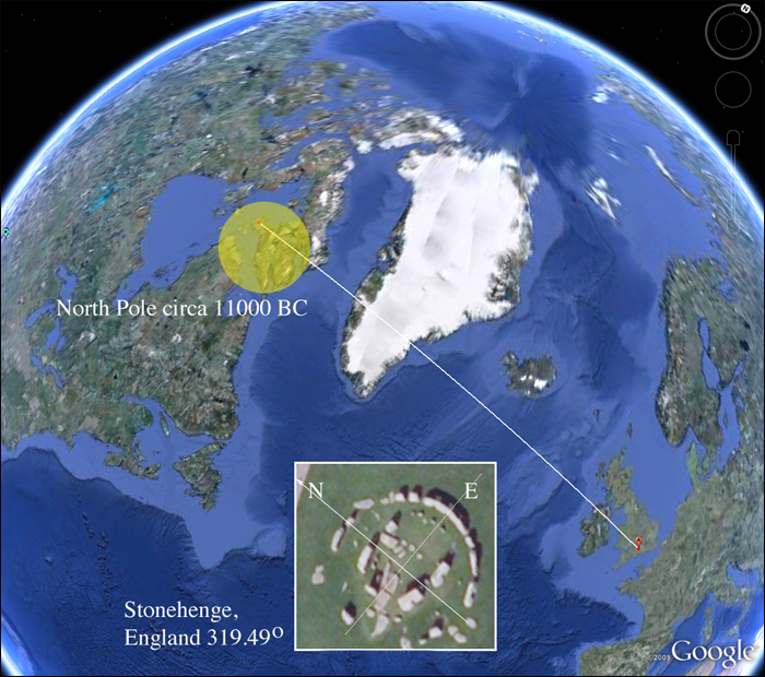
Mills proposed that Stonehenge would have been the perfect "wheel of truth" if only the North Pole were not where it is now. He sent his ideas to viewzone's editor, Gary Vey, who decided to use google earth to see where the "perfect" North Pole would have to be. The results [below] show that the exact alignment of this North Pole is where Hapgood predicted it to be at about 11,000 BC! This suggests a much greater antiquity for Stonehenge than is currently estimated.
The Avenue of the Dead
Another anomaly that has perplexed archaeologists has to do with the ancient pyramid site called Teotihuacan, also known as The Avenue of the Dead. It consists of several step pyramids situated along a straight corridor. But the corridor (or avenue) doesn't align with anything. It is in the northern direction but not exactly North. For a civilization that was known for its precision and calulating, this seems very odd.
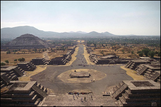
Teotihuacan is an enormous archaeological site in the Basin of Mexico, containing some of the largest pyramidal structures built in the pre-Columbian Americas. Apart from the pyramidal structures, Teotihuacan is also known for its large residential complexes, the Avenue of the Dead, and numerous colorful, well-preserved murals.
The early history of Teotihuacan is quite mysterious, and the origin of its founders is debated. For many years, archaeologists believed it was built by the Toltec. This belief was based on colonial period texts, such as the Florentine Codex, which attributed the site to the Toltecs. However, the Nahuatl word "Toltec" generally means "craftsman of the highest level" and may not always refer to the Toltec civilization centered at Tula, Hidalgo. Since Toltec civilization flourished centuries after Teotihuacan, the people could not have been the city's founders.
Using google earth again, we extended a line along the "avenue" and found that it did align with the North Pole as it existed 12,000 to 17,000 years ago.
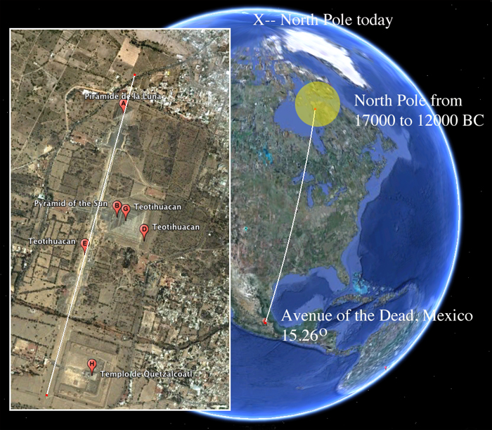
Does this suggest that the site is much older than we currently estimate? I believe it does. The geographical layout of Teotihuacan is aligned to 15.26º east of North. One theory says this is due to the fact that the sun rose at that same angle during the same summer day each year. Settlers used the alignment to calibrate their sense of time or as a marker for planting crops or performing certain rituals. Another theory is that there are numerous ancient sites in Mesoamerica that seem to be oriented with the tallest mountain in their given area. But perhaps the site was constructed over the ruins of a much older, ancient city.
Adams calendar -- how old?
Viewzone recently ran a story on an alleged 200,000 year old settlement that was recently discovered in South Africa (see Adam's Calendar). Aside from thousands of foundations and walled streets and paths, an astronomical stone calendar was found, almost completely intact, on the top of a mountain just above the old settlement.
The positioning of the stones is quite amazing and shows alignment with Mill's "wheel of truth." There are stoned to calculate the equinox and solstice. But once again the North and South stones do not align perfectly with the current directions.
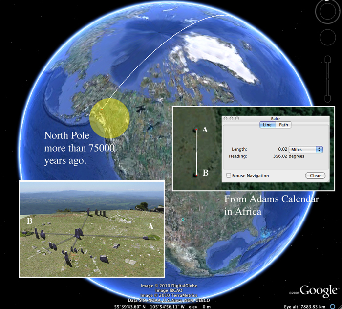
Using google earth we extended a line through the South and North stone markers and saw it intersect with the North Pole as it would have been positioned about 75,000 years ago. This is the earliest date for which we have geomagnetic evidence of a magnetic pole. While we can only speculate that even earlier polar positions existed we can use this as evidence that the Adams Calendar site is at least this old.
Baalbek
The history settlement in the area of Baalbek dates back approximately 9000 years, with almost continual settlement of the tell under the Temple of Jupiter. The base of the famous Temple of Jupiter is made of huge stones that weigh as much as 300 tons! How they were carved and moved in to place remains a mystery.
In his books on ancient history, Zecharia Sitchin proposed that the site was much older than 9000 years and suggested it might have been used by extraterrestrials as a base for their space vehicles. We tested his hypothesis by locating the East alignment for the temples foundation and ten extended a line North.
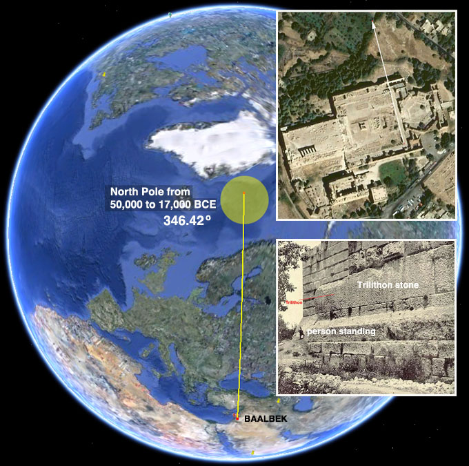
We can see that the North line intersects perfectly with the North Pole as is calculated to be from about 50,000 years ago to about 17,000 BCE. This is the only alignment of the foundation that makes any sense.
Tiahuanaco, Bolivia
Ask most people who are the oldest civilization or where the oldest civilization lived and you'll here answers like Mesopotamia (Iraq), Egypt or Iran. While these cultures can be traced back to 4000 B.C., the mysterious ruins of Tiahuanaco, in Bolivia, are thought to be 14,000 years old!
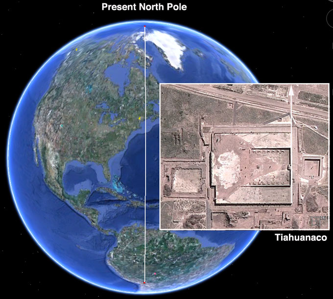
We tested this theory by aligning the famous Sun Gate and the surrounding temple to face the rising sun -- exactly East. Then we traced the North line at 360 degrees to, where else, the present North Pole. This means that the temple and the Sun Gate were aligned sometime between 12,000 BCE and the present.
Angkor Wat, Cambodia
Angkor Wat (or Angkor Vat) is a temple complex at Angkor, Cambodia, built for the king Suryavarman II in the early 12th century as his state temple and capital city. As the best-preserved temple at the site, it is the only one to have remained a significant religious centre since its foundation -- first Hindu, dedicated to the god Vishnu, then Buddhist. The temple is the epitome of the high classical style of Khmer architecture. It has become a symbol of Cambodia, appearing on its national flag, and it is the country's prime attraction for visitors.
Suryavarman is said to have selected the site based on some extremely ancient artifacts that were found there. So, once again we looked for the orientation of the foundations to see which position of North was used.
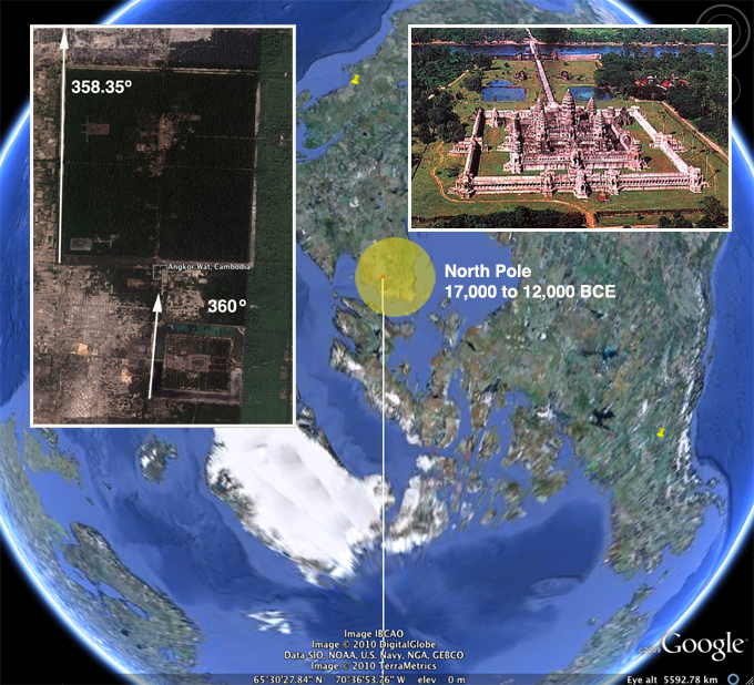
Surprisingly, there are two different orientations found at the site. One is dead-on 360 degrees -- obviously the North Pole of today. The other is off by a few degrees (as seen in the photo above) and aligns with the position of the North Pole for the period 17,000 to 12,000 BCE.
There is one other anomaly worth mentioning.
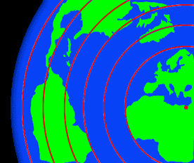
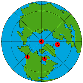
The distance from the North Pole to the Equator is about 6215 miles. This is exactly the distance for Angkor Wat to the second pole position located in Alaska. And if a line of 6215 miles is extended from this second position it intersects with the Nazca Lines in Peru, Easter Island, Persepolis, Petra, Anatom Island, the Great Pyramid, and Mohenjodaro in Pakistan. This means that all of these sacred sites were once on the Equator when the North Pole was in the Second Position (50,000 years ago!). Coincidence?
The Magnetic Poles are moving again!
The North polar axis is different from the magnetic North that a compass points to. This discrepancy is often used to support the Shifting Pole theory because it shows that the core, responsible for creating the magnetic field, is not aligned with the rotational axis of the planet. Over time, the two should be more or less identical.
If we have had crustal shift in the past, we ought to see the magnetic North moving toward the North axis. In fact, this is exactly what we do see.
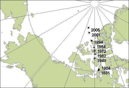
The magnetic north pole had moved little from the time scientists first located it in 1831. Then in 1904, the pole began shifting northeastward at a steady pace of about 9 miles (15 kilometers) a year.
In 1989 it sped up again, and in 2007 scientists confirmed that the pole is now galloping toward Siberia at 34 to 37 miles (55 to 60 kilometers) a year! Is this fast? To put it in perspective, the last shift from Position #3 (in the Northeast shore of Hudson Bay) to the present Position #4 (the current North Pole) covered just 2000 miles. Traditional scientists like to imagine that this took thousands of years to happen. Remember, Hapgood believed this happened suddenly. At the current rate at which the poles are moving, this same distance would take just 55 years!
Food for thought
Second super-fast flip of Earth's poles found -- reported in www.newscientist.com:
SOME 16 million years ago, north became south in a matter of years. Such fast flips are impossible, according to models of the Earth's core, but this is now the second time that evidence has been found.
The magnetic poles swap every 300,000 years, a process that normally takes up to 5000 years. In 1995 an ancient lava flow with an unusual magnetic pattern was discovered in Oregon. It suggested that the field at the time was moving by 6 degrees a day - at least 10,000 times faster than usual. "Not many people believed it," says Scott Bogue of Occidental College in Los Angeles.
Now Bogue and his colleague Jonathan Glen of the United States Geological Survey in Menlo Park, California, say they have found a second example in Nevada. The lava rock suggests that in one year, Earth's magnetic field shifted by 53 degrees (Geophysical Research Letters, DOI: 10.1029/2010GL044286). At that rate, a full flip would take less than four years, but there could be another interpretation. "It may have been a burst of rapid acceleration that punctuated the steady movement of the field," says Bogue.
Peter Olson of Johns Hopkins University in Baltimore, Maryland, remains sceptical and points out that the effects could have been local rather than global.
Earth is overdue for a reversal, and rapid shifts would cause widespread chaos - for navigation and migratory birds for instance.
|


 Reply With Quote


Bookmarks