
This is yet another storm that no one is going to get right. They are 0-6.
I'm predicted to get 3 inches. I suspect I'll either get 0 or a foot.


This is yet another storm that no one is going to get right. They are 0-6.
I'm predicted to get 3 inches. I suspect I'll either get 0 or a foot.
"Far better it is to dare mighty things, to win glorious triumphs even though checkered by failure, than to rank with those poor spirits who neither enjoy nor suffer much because they live in the gray twilight that knows neither victory nor defeat."
-- Theodore Roosevelt

We're back to tiny flakes. With what I'm seeing I'm starting to get a little concerned you could be right Mal. Hopefully my concerns are unfounded because this is supposed to be a long running event...
Recent update from ILN:
AREA FORECAST DISCUSSION
NATIONAL WEATHER SERVICE WILMINGTON OH
1100 AM EST MON FEB 16 2015
.SYNOPSIS...
VERY COLD ARCTIC HIGH PRESSURE WILL SLIDE SLOWLY EAST AS LOW
PRESSURE TRACKS FROM THE SOUTHERN PLAINS THROUGH THE TENNESSEE
VALLEY THROUGH TONIGHT. THIS SYSTEM WILL BRING SIGNIFICANT SNOW TO
PORTIONS OF THE OHIO VALLEY TODAY. A DISTURBANCE WILL WORK THROUGH
THE REGION TUESDAY AFTERNOON INTO WEDNESDAY OFFERING A CHANCE FOR
SOME SNOW SHOWERS. A REINFORCING SHOT OF ARCTIC AIR WILL OFFER
VERY COLD TEMPERATURES AND DRY CONDITIONS FOR THE END OF THE WEEK.
&&
.NEAR TERM /UNTIL 6 PM THIS EVENING/...
-- Changed Discussion --A FAIRLY SIGNIFICANT WINTER STORM IS UNDERWAY ACROSS THE FAR
SOUTHERN PORTION OF THE NWS ILN FORECAST AREA. THE MAIN FOCUS FOR
THIS UPDATE WAS TO ASSESS CURRENT RADAR AND OBSERVATIONAL TRENDS
IN ORDER TO ADJUST THE GOING SNOWFALL FORECAST NUMBERS...IN
ADDITION TO EXAMINING FORCING MECHANISMS TO DETERMINE WHERE
ADDITIONAL HEAVY SNOW WILL BE LIKELY.
FRIGID HIGH PRESSURE IS CURRENTLY CENTERED OVER LAKE ERIE...AND
BASED ON SURFACE OBS FROM NEAR THE SHORELINE...IT APPEARS THAT
THIS HIGH WAS INITIALIZED A LITTLE TOO WEAK ON THE 12Z MODEL RUNS.
THIS MIGHT HELP TO EXPLAIN A FEW THINGS OBSERVED THIS MORNING THAT
DIFFERED SLIGHTLY FROM PREVIOUS FORECASTS. TEMPERATURES...WHICH
HAD BEEN FORECAST TO RISE ONLY SLIGHTLY TODAY...HAVE YET TO EVEN
BEGIN TO DO THAT. THE NEW MAX TEMPERATURE FORECAST IS THUS REDUCED
A LITTLE BIT...AND MAY STILL BE TOO OPTIMISTIC GIVEN TRENDS OVER
THE PAST TWO HOURS. IN ADDITION...THE PERSISTENCE OF THIS DRIER
AIR MASS MAY BE HAVING AN IMPACT ON THE ABILITY FOR THE NORTHERN
EDGE OF THE DEVELOPING SNOW TO BEGIN REACHING THE GROUND.
ULTIMATELY...IT APPEARS THAT THE BIGGEST PERSISTENT FORCING
THROUGH THIS EVENT WILL BE WITH STRONG FRONTOGENESIS NEAR 700MB
WEST-TO-EAST ACROSS KENTUCKY. ALTHOUGH SOME FRONTOGENESIS IS
EXPECTED TO DEVELOP A LITTLE LOWER IN THE ATMOSPHERE...AND FURTHER
TO THE NORTH...THIS APPEARS UNLIKELY TO BEGIN UNTIL LATER IN THE
EVENT (AND PRIMARILY ACROSS THE SOUTHEAST PORTION OF THE ILN
FORECAST AREA). WEAK DEFORMATION IS ALSO FORECAST ACROSS THE
SOUTHERN HALF OF THE FORECAST AREA...ALSO STRENGTHENING ONLY AS IT
BEGINS TO PIVOT OFF TO THE SOUTHEAST. FURTHER ALOFT...THE ENTIRE
SOUTHERN OHIO VALLEY IS IN A FAVORABLE REGION FOR LIFT...WITH THE
JET AT 300MB STRETCHING FROM SOUTHERN MICHIGAN THROUGH NEW JERSEY.
THERE HAVE BEEN TWO STORIES TO THE WEATHER SO FAR IN THIS EVENT.
THE FIRST IS THE IMPRESSIVE TOTALS ALREADY OBSERVED IN THE
SOUTHWESTERN CWA...AS A BAND OF SNOW SET UP ACROSS SOUTHERN
INDIANA AND INTO SWITZERLAND/GALLATIN COUNTIES IN THE ILN FORECAST
AREA. NUMEROUS RELIABLE REPORTS OF OVER FOUR INCHES HAVE ALREADY
BEEN RECEIVED...AND IT IS EXPECTED THAT TOTALS ARE PROBABLY
AROUND SIX INCHES ALREADY IN SOME SPOTS...WITH THE EVENT LESS THAN
HALF OVER. AS MENTIONED ABOVE...THERE IS CONFIDENCE IN CONTINUED
STEADY SNOW ACROSS THIS AREA...AND STRETCHING ACROSS THE ILN
NORTHERN KENTUCKY COUNTIES. THERE APPEARS TO BE A TIME PERIOD IN
THE MID TO LATE AFTERNOON IN WHICH DEEPENING FRONTOGENESIS AND
DEFORMATION WILL JUXTAPOSE AS THEY PIVOT ACROSS THE SOUTHEASTERN
FORECAST AREA. FOR THIS REASON...SNOW TOTALS WERE INCREASED
SLIGHTLY FROM MASON COUNTY KENTUCKY THROUGH SCIOTO COUNTY OHIO.
WITH SNOW NOT EXPECTED TO END FOR THESE LOCATIONS UNTIL LATE
EVENING...THERE IS HIGH CONFIDENCE IN SIGNIFICANT ACCUMULATIONS.
THE SECOND STORY IS THE LACK OF ACCUMULATING SNOW FURTHER NORTH
ACROSS THE FORECAST AREA. DRIER AIR AND WEAKER FORCING HAVE SO FAR
KEPT MUCH FROM DEVELOPING ON THE NORTH END OF THE PRECIPITATION
SHIELD. SNOW OBSERVED SO FAR IN WILMINGTON HAS BEEN VERY
FINE...SUGGESTING THAT ALTHOUGH THE TEMPERATURE TRACE SPENDS QUITE
A BIT OF TIME IN THE DENDRITIC GROWTH ZONE BELOW 5000 FEET...THERE
SIMPLY IS NOT ENOUGH MOISTURE OR LIFT IN THIS LAYER TO PRODUCE
BIGGER FLAKES AND BIGGER ACCUMULATIONS. THERE IS CERTAINLY
EXPECTED TO BE AN INCREASE IN COVERAGE AND SNOWFALL INTENSITY
DURING THE EARLY TO MID AFTERNOON ACROSS THIS AREA.
HOWEVER...THERE WAS NO CHOICE BUT TO REDUCE SNOWFALL AMOUNTS ALONG
THE NORTHERN EDGE. THESE NEW NUMBERS ARE EVEN SLIGHTLY BELOW SOME
OF THE OUTPUT FROM VARIOUS 12Z MODELS...BUT THESE MODELS SUGGESTED
ACCUMULATIONS BY 16Z THAT HAVE NOT OCCURRED. THE END RESULT OF THE
CHANGES TO THE SNOW FORECAST IS A FURTHER TIGHTENING OF THE
GRADIENT...WITH A REDUCTION ON THE NORTHERN EDGE...AND A VERY
SLIGHT ADJUSTMENT UPWARD IN THE SOUTHERN TIER OF THE ILN FORECAST
AREA.-- End Changed Discussion --
Northern fringe is a sharp cutoff....you a probably in the suck zone and get a flurry.
"Far better it is to dare mighty things, to win glorious triumphs even though checkered by failure, than to rank with those poor spirits who neither enjoy nor suffer much because they live in the gray twilight that knows neither victory nor defeat."
-- Theodore Roosevelt
The Euro has backed off of snow totals too. Here's a comparison of the 0z to the 12z through tomorrow. I've gone from 9-10" to 6-7".
0z
12z

Intensity has just picked up and flakes are back at medium size. My grass is completely covered. I'd estimate we're at 1.5-2" right now.Originally Posted by Malsua

Going to go out on a limb right now and say no 4 day weekend for me.
I say Virga will eat up anything coming my way...so 1 inch at best, probably due to 30:1 ratio.
"Far better it is to dare mighty things, to win glorious triumphs even though checkered by failure, than to rank with those poor spirits who neither enjoy nor suffer much because they live in the gray twilight that knows neither victory nor defeat."
-- Theodore Roosevelt
SREF Mean down to between 5.5-6"
The radar returns for this storm are "bleak" for QPF and what is falling is getting sucked into the dry air.
I don't expect any snow at this point.
Even areas in South Jersey that were going to get 8-12 will be lucky to see 3.
This is a garbage storm.
"Far better it is to dare mighty things, to win glorious triumphs even though checkered by failure, than to rank with those poor spirits who neither enjoy nor suffer much because they live in the gray twilight that knows neither victory nor defeat."
-- Theodore Roosevelt
Yep, spot on. This is turning into quite a disappointment. Was really looking like it was going to be a monster but the dry air killed it.
At this point we're almost completely out of the last remaining snow band.
We'll probably end up with another inch or so based on that.
I think that will put us at about 5" or so. On par with the pre-Thanksgiving storm and more than anything else this Winter. Quite a bit less than I was hoping for though.
I haven't gone out to make multiple measurements for anything official because it is damned cold out but I definitely got about 5" total. A healthy snow but, admittedly, quite a bit less than I was hoping for. Better than nothing though I suppose.
I think there was 1 inch on the ground when I left this morning. It was more than I expected.
"Far better it is to dare mighty things, to win glorious triumphs even though checkered by failure, than to rank with those poor spirits who neither enjoy nor suffer much because they live in the gray twilight that knows neither victory nor defeat."
-- Theodore Roosevelt
I took a picture yesterday of the snow we got starting Saturday afternoon. It was a heavy snow at first then turned to finer flakes.
The picture was of a table on the deck. There's easily 8" of snow on it. I'll try to post it tonight.
It was 9 degrees this morning when I left.
Who left the damned freezer open?
I fucking HATE the cold.
Libertatem Prius!
To view links or images in signatures your post count must be 15 or greater. You currently have 0 posts.
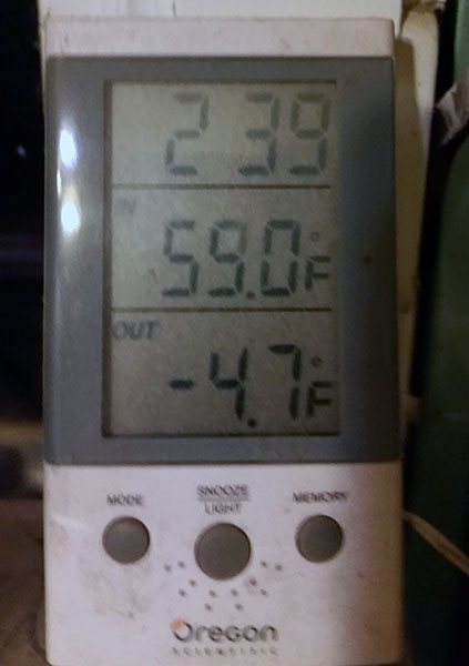
The clock is wrong but this was about 5am on Monday when I took the dog out.
It's been a while since it was this cold.
"Far better it is to dare mighty things, to win glorious triumphs even though checkered by failure, than to rank with those poor spirits who neither enjoy nor suffer much because they live in the gray twilight that knows neither victory nor defeat."
-- Theodore Roosevelt
That's not cold.
lol
Libertatem Prius!
To view links or images in signatures your post count must be 15 or greater. You currently have 0 posts.
No, it's not cold compared to Alaska and it has been as cold as -20F, but it's still pretty cold.
Not exactly t-shirt weather.
"Far better it is to dare mighty things, to win glorious triumphs even though checkered by failure, than to rank with those poor spirits who neither enjoy nor suffer much because they live in the gray twilight that knows neither victory nor defeat."
-- Theodore Roosevelt
We had those neg 12-15 temps awhile back (think it was November or December). It was COLD and HURT. lol
But I was being sarcastic anyway, at this point in my life any thing below about 50 degrees is cold now. haha
Libertatem Prius!
To view links or images in signatures your post count must be 15 or greater. You currently have 0 posts.

Yea, back in Novemer we went through a wicked cold spell. Morning temps were -20 to -25 and the wind was relentless driving windchills to -50. A lot of the oil service companies pulled crews to minimal shifts just to maintain wells and put everything else on hold. Both men and machines just don't work too well at that temp anyway. Been pretty decent since then in the teens and 20's.
I thought it was November. I remember it being the wrong time of year. I expect those temps during THIS month, but NO....
This last two weeks have been decent. We had a lot of snow starting about Saturday afternoon going until last night though. If I remember I'll post a picture of the deck from yesterday morning.
Libertatem Prius!
To view links or images in signatures your post count must be 15 or greater. You currently have 0 posts.
here you go...
This was taken on Monday morning. Was snowing like hell and that's pretty much what fell from Saturday night through Monday morning.
Libertatem Prius!
To view links or images in signatures your post count must be 15 or greater. You currently have 0 posts.
There are currently 39 users browsing this thread. (0 members and 39 guests)
 Posting Permissions

 Reply With Quote


Bookmarks